1990s Maps of Cherry Hill Township, New Jersey
Explore 3 historic maps of Cherry Hill Township from the 1990s. These maps offer a rare glimpse into what life looked like during the 1990s — showing old roads, neighborhoods, homes, and landmarks that have changed or disappeared over time.
Whether you're researching your family's past, planning a metal detecting trip, or studying how Cherry Hill Township's landscape evolved across the 1990s, these high-resolution maps are a powerful tool for exploring the history of this region.
- Focus on a specific era: All maps on this page are from the 1990s, giving you a focused view of this time period.
- See what’s changed: Compare century-old streets, trails, and buildings to today's modern landscape using overlays and satellite layers.
- Research with precision: Use these maps for genealogy, historical research, land use analysis, or educational projects.
- View, download, or print: Maps are fully viewable online in high resolution, and can be downloaded or printed for your own records.
Start exploring Cherry Hill Township's history through authentic maps from the 1990s. This is your window into the past.
Cherry Hill Township, NJ maps
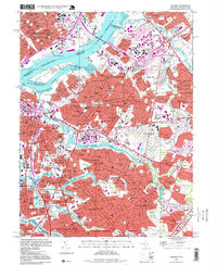
(3)- 1995 Map of Moorestown, 1998 Print
 1995 Moorestown1998 Print · USGSSouth Jersey's suburban landscape reached a peak of development in the late nineties, centered on the busy intersection of the New Jersey Turnpike. Researchers can trace the layout of residential tracts like Heritage Village or locate historic sites like Colestown Cemetery and the Cistercian Monastery.
 - 1995 Map of Camden, 1999 Print
 1995 Camden1999 Print · USGSThe Delaware River waterfront in the 1990s remains a hub of industry and transit connecting New Jersey to Philadelphia. Family researchers can trace deep roots through detailed layouts of Harleigh Cemetery, Old Camden Cemetery, and dozens of local parish schools like St Josephs High Sch.
 - 1995 Map of Runnemede, 2000 Print
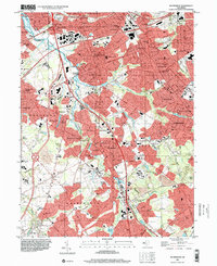 1995 Runnemede2000 Print · USGSCamden and Gloucester counties are shown here in the mid-nineties as the suburban landscape fully integrated with major regional thoroughfares. Researchers can trace historic neighborhoods and community anchors like Blackwood Terrace, St Johns Ch, and the Pennsylvania-Reading Seashore Lines.
End of results
Showing maps 1-3 of 3
Top cities near Cherry Hill Township
- Philadelphia historical maps
- Camden historical maps
- Bensalem Township historical maps
- Abington Township historical maps
- Washington Township historical maps
- Sicklerville historical maps
See more
Top neighborhoods of Cherry Hill Township
- Brookfield historical maps
- Cherry Hill Estates historical maps
- Columbia Lakes historical maps
- Colwick historical maps
- Tyndall Village historical maps
- Barclay Farm historical maps
See more
Frequently asked questions
- What are the different types of historical maps available for Cherry Hill Township?
- What is the oldest map of Cherry Hill Township?
- Where can I purchase historical maps of Cherry Hill Township for my home or office?
- Where can I download high-res historical maps of Cherry Hill Township?
- Are there historical topographic maps available for Cherry Hill Township?
- Is there historical aerial imagery available for Cherry Hill Township?
- Where are historical maps of Cherry Hill Township sourced from?