Old Maps of Avalon, New Jersey for Academic Research
Study the evolution of Avalon with 30 high-resolution historic maps. Whether you're teaching, researching, or modeling changes in land use, these maps provide essential visual documentation of urban, environmental, and geographic change.
- Analyze long-term change: Track patterns in development, transportation, and natural features.
- Ideal for environmental or urban studies: Support academic projects with primary historical map data.
- Use in the classroom or lab: Educators and researchers rely on these maps to bring historical context to life.
These maps are a powerful tool for teaching, research, and visualizing how Avalon has changed over the decades.
Avalon, NJ maps
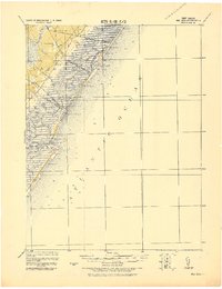
(30)- 1884 Map of Sea Isle
 1884 Sea Isle1884 Print · USGSThe Jersey Shore emerges as a Victorian-era destination in this late nineteenth-century survey of the Cape May coast. Trace the early rail lines of the West Jersey Railroad and locate maritime landmarks like L.S. Station Sea Isle City and Corson's Inlet.
 - 1888 Map of Dennisville
 1888 Dennisville1888 Print · USGSCoastal Cape May County thrived in the late nineteenth century as a network of rail lines and tide-water landings. Genealogists can trace family names and vanished settlements from Cape May Court House to the West Jersey Railroad depots at Swain Station and Burleigh.
 - 1888 Map of Sea Isle
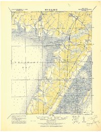
 1888 Sea Isle1888 Print · USGSCoastal Cape May County emerges in the 1880s as railroads began to bridge the marshes. Trace the early development of Sea Isle City and the locations of maritime safety outposts like L. S. Station Townsend's Inlet and L. S. Station Tatham's.
 - 1894 Map of Dennisville
 1894 Dennisville1894 Print · USGSCape May County's maritime and rail landscape is captured here in the late nineteenth century before the modern development of the shore. Genealogists and historians can trace old family settlements and landings like Nummytown, Goshen Landing, and Heislerville.4 unique versions available
 - 1894 Map of Sea Isle
 1894 Sea Isle1894 Print · USGSThe Cape May coast at the end of the nineteenth century reveals a landscape of complex tidal thorofares and early seaside resorts. Trace the path of the West Jersey Railroad and find early maritime landmarks like L.S. Station Corson Inlet.6 unique versions available
 - 1919 Map of Sea Isle, 1921 Print
 1919 Sea Isle1921 Print · USGSCoastal Cape May at the end of the Great War reveals a landscape of tidal thoroughfares and early rail-connected resorts. Researchers can trace the tracks of the Penna. R.R. through Ocean View or locate old shore landmarks like L.S.S. Corson Inlet.
 - 1919 Map of Dennisville, 1921 Print
 1919 Dennisville1921 Print · USGSCape May County's southern peninsula is documented here during the height of the coastal rail era, before modern development reshaped the shoreline. Genealogists and historians can trace the foundations of local commerce through sites like Bidwell Town Mill, Goshen Landing, and the many family-named stops along the Philadelphia & Reading R.R.
 - 1941 Map of Dennisville
 1941 Dennisville1941 Print · USGSCape May County's interior and coastal marshes are captured here in the early 1940s, from the bay-side landings to the Atlantic sounds. Trace the rail corridors of the Pennsylvania-Reading Seashore Lines through Dennisville and locate the State Prison Farm.2 unique versions available
 - 1941 Map of Sea Isle City
 1941 Sea Isle City1941 Print · USGSCoastal Cape May County is captured here in the early days of the Second World War, showing the delicate balance of tidal marshes and growing seaside resorts. Genealogists and historians can trace rail lines to Sea Isle City or locate landmarks like the Ludlam Beach Light and the community of Strathmere.
 - 1944 Map of Stone Harbor
 1944 Stone Harbor1944 Print · USGSCoastal Cape May County thrived as a rail-linked summer destination during the mid-1940s, balancing mainland hubs with growing seaside resorts. Researchers can trace the heritage of Whitesboro and Mayville or locate landmarks like the Stone Harbor CG Station and Bowers Municipal Fishing Pier.3 unique versions available
 - 1946 Map of Wilmington, 1948 Print
 1946 Wilmington1948 Print · USGSThe Delaware Valley and Jersey Shore emerge in this mid-century portrait of a region defined by river commerce and seaside growth. Genealogists and historians can trace the rail networks of the Pennsylvania Railroad, locate early airfields like Dover Airpark, and find river defenses at Fort Delaware.2 unique versions available
 - 1953 Map of Avalon, 1957 Print
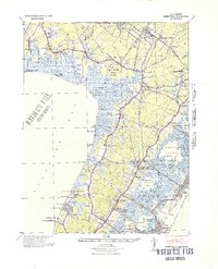
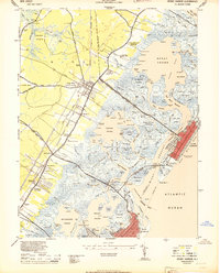
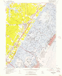
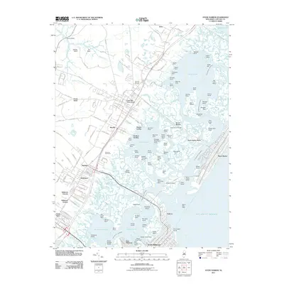
 1953 Avalon1957 Print · USGSThe Jersey Shore communities of Avalon and Stone Harbor appear in the early fifties, just as the postwar coastal boom was taking hold. Researchers can trace the development of Seven Mile Beach, identifying local landmarks like the Avalon Yacht Club, the original Boardwalk, and the harbors along the Intracoastal Waterway.4 unique versions available
 - 1955 Map of Wilmington
 1955 Wilmington1955 Print · USGSThe Delaware Valley and Jersey Shore are seen here during the mid-fifties era of rapid suburban expansion and highway development. You can trace the path of the New Jersey Turnpike, locate the Fort Dix Military Reservation, or explore the rail networks of the Pennsylvania Railroad.
 - 1955 Map of Stone Harbor, 1957 Print
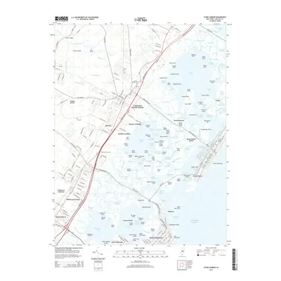
 1955 Stone Harbor1957 Print · USGSThe Jersey Shore is captured mid-century as the Garden State Parkway began reshaping the coastal landscape. Trace the old rail lines and inland settlements like Whitesboro and Mayville, or explore the established grid of Stone Harbor.5 unique versions available
 - 1957 Map of Wilmington
 1957 Wilmington1957 Print · USGSThe mid-Atlantic coastal plain comes alive in the mid-fifties as the New Jersey Turnpike and Garden State Parkway redefine travel. Researchers can trace the rail-to-road transition and find landmarks like Ship John Shoal Light and the Fort Dix Military Reservation.2 unique versions available
 - 1959 Map of Wilmington
 1959 Wilmington1959 Print · USGSThe Delaware Valley and Jersey Shore are seen here in the late fifties, during a period of massive suburban and highway expansion. Researchers can trace mid-century infrastructure like the N J Turnpike or locate coastal landmarks from Barnegat Bay to the Maurice River.3 unique versions available
 - 1966 Map of Wilmington, 1968 Print
 1966 Wilmington1968 Print · USGSThe Delaware Valley and Jersey Shore are seen here in the mid-1960s, documenting a landscape of dense industrial cities and emerging coastal resorts. Researchers can trace the sprawling rail networks of the Pennsylvania Railroad or locate landmarks like Fort Dix Military Reservation and Elk Neck State Park.4 unique versions available
 - 1972 Map of Wilmington, 1976 Print
 1972 Wilmington1976 Print · USGSThe Delaware Valley and Jersey Shore are seen here in the 1970s, showcasing the region's dense transport networks and vast state forests. Trace early coastal development near Atlantic City or locate rural landmarks like Mount Holly and Dover Air Force Base.2 unique versions available
 - 1984 Map of Atlantic City, 1985 Print
 1984 Atlantic City1985 Print · USGSThe Jersey Shore and Pine Barrens are captured here in the mid-eighties, showing the coastal transition from salt marsh to forest. Genealogists and historians can trace family locations from Estell Manor to North Wildwood or explore the vast bounds of the Belleplain State Forest.
 - 1994 Map of Avalon, 1998 Print
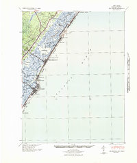
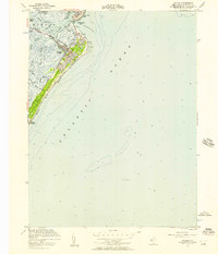
 1994 Avalon1998 Print · USGSThe Jersey Shore of the 1990s comes alive in this detailed record of Avalon and the northern tip of Stone Harbor. Local historians and boaters can trace the development of Seven Mile Beach, from the Boardwalk to the man-made inlets of Princeton Harbor.
 - 2011 Map of Stone Harbor, 2011 Print
 2011 Stone Harbor2011 Print · USGSCovers Avalon, including Lower Township, Middle Township, and other nearby areas
 - 2011 Map of Avalon, 2011 Print
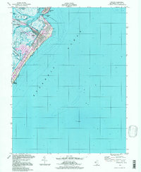
 2011 Avalon2011 Print · USGSCovers Avalon, including Middle Township, Sea Isle City, and other nearby areas
 - 2014 Map of Stone Harbor, 2014 Print
 2014 Stone Harbor2014 Print · USGSCovers Avalon, including Lower Township, Middle Township, and other nearby areas
 - 2014 Map of Avalon, 2014 Print
 2014 Avalon2014 Print · USGSCovers Avalon, including Middle Township, Sea Isle City, and other nearby areas
 - 2016 Map of Stone Harbor, 2016 Print
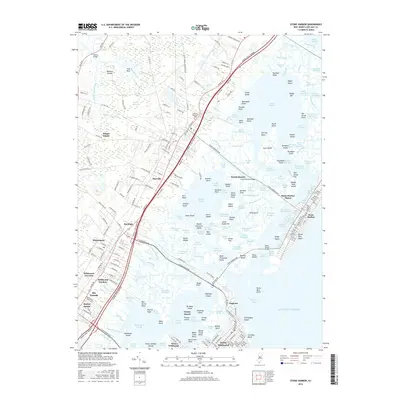 2016 Stone Harbor2016 Print · USGSCovers Avalon, including Lower Township, Middle Township, and other nearby areas
Showing maps 1-25 of 30
Top cities near Avalon
- Egg Harbor Township historical maps
- Lower Township historical maps
- Middle Township historical maps
- Ocean City historical maps
- Upper Township historical maps
- Somers Point historical maps
See more
Frequently asked questions
- What are the different types of historical maps available for Avalon?
- What is the oldest map of Avalon?
- Where can I purchase historical maps of Avalon for my home or office?
- Where can I download high-res historical maps of Avalon?
- Are there historical topographic maps available for Avalon?
- Is there historical aerial imagery available for Avalon?
- Where are historical maps of Avalon sourced from?