Old Maps of Lower Township, New Jersey for Hiking & Exploration
Hike through history with 55 historic maps of Lower Township. Explore old trails, ghost towns, and forgotten backroads — perfect for outdoor adventurers and local explorers.
- Rediscover forgotten places: Map out old mining camps, roads, and footpaths that no longer exist on modern maps.
- Layer with modern tools: Combine with LiDAR or satellite views to plan hikes through historical terrain.
- Made for exploration: Popular among hikers, overlanders, and local history lovers.
Use these maps to find adventure and explore the hidden past of Lower Township.
Lower Township, NJ maps
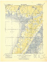
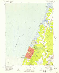
(55)- 1888 Map of Cape May
 1888 Cape May1888 Print · USGSCape May County's southern shoreline is captured in the late nineteenth century as Victorian resorts and maritime stations defined the coast. Genealogists and historians can trace early railroad lines like the Cape May and Sewell's Point R.R. or locate legacy landmarks such as Higbee's Landing and Cape May Point.
 - 1888 Map of Dennisville
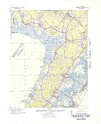
 1888 Dennisville1888 Print · USGSCoastal Cape May County thrived in the late nineteenth century as a network of rail lines and tide-water landings. Genealogists can trace family names and vanished settlements from Cape May Court House to the West Jersey Railroad depots at Swain Station and Burleigh.
 - 1893 Map of Cape May
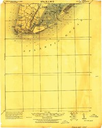
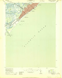
 1893 Cape May1893 Print · USGSThe tip of the Jersey Shore appears here in the late Victorian era, before modern development reshaped its coastlines and sounds. Genealogists and historians can trace early settlements like Cold Spring, coastal landmarks like the Cape May Light, and several Life Saving Stations along the shore.4 unique versions available
 - 1894 Map of Dennisville
 1894 Dennisville1894 Print · USGSCape May County's maritime and rail landscape is captured here in the late nineteenth century before the modern development of the shore. Genealogists and historians can trace old family settlements and landings like Nummytown, Goshen Landing, and Heislerville.4 unique versions available
 - 1898 Map of Cape May, 1904 Print
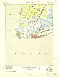
 1898 Cape May1904 Print · USGSThe tip of the Jersey Shore at the close of the nineteenth century reveals a landscape of early beach resorts and vital rail connections. Researchers can trace the original footprints of Holly Beach and Cape May Point, or locate maritime landmarks like the Cape May Light and several federal life-saving stations.
 - 1918 Map of Cape May, 1921 Print
 1918 Cape May1921 Print · USGSCoastal New Jersey is shown here at the height of its early railroad era, before modern development transformed the shoreline. Genealogists and historians can trace rail lines to Cape May City, find old Life Saving Stations, and locate vanished spots like Schellinger's Landing or Bennet.
 - 1919 Map of Dennisville, 1921 Print
 1919 Dennisville1921 Print · USGSCape May County's southern peninsula is documented here during the height of the coastal rail era, before modern development reshaped the shoreline. Genealogists and historians can trace the foundations of local commerce through sites like Bidwell Town Mill, Goshen Landing, and the many family-named stops along the Philadelphia & Reading R.R.
 - 1925 Map of Cape May
 1925 Cape May1925 Print · USGSThe tip of the New Jersey peninsula is shown in detail during the early twentieth century, featuring a landscape of burgeoning resort towns and maritime defenses. Researchers can trace early railroad lines, find long-standing landmarks like Cape May Light, and explore vanished coastal features such as L.S. Station Turtle Gut.
 - 1940 Map of Cape May, 1941 Print
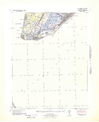 1940 Cape May1941 Print · USGSCape May County's southern tip was a critical defensive and resort hub during the early fortie. Genealogists and researchers can trace the precise streets of Wildwood, identify the military footprint at the Naval Res, and locate vanished landmarks at South Cape May.
 - 1941 Map of Cape May
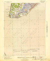 1941 Cape May1941 Print · USGSCape May County is caught at a pivotal moment in the early 1940s as coastal defenses and resort life coexist. Researchers can trace the legacy of vanished landmarks and transit routes like the Reading Lines railroad, South Cape May, and the U. S. Naval Res.
 - 1941 Map of Dennisville
 1941 Dennisville1941 Print · USGSCape May County's interior and coastal marshes are captured here in the early 1940s, from the bay-side landings to the Atlantic sounds. Trace the rail corridors of the Pennsylvania-Reading Seashore Lines through Dennisville and locate the State Prison Farm.2 unique versions available
 - 1944 Map of Wildwood
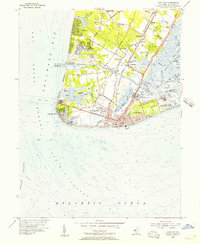
 1944 Wildwood1944 Print · USGSThe Wildwoods are captured here during the mid-1940s as thriving coastal resorts tied together by the Pennsylvania-Reading Seashore Lines. Local historians can trace the development of North Wildwood down to Wildwood Gables, alongside maritime sites like the Ocean Pier and Cold Spring Harbor Dock.2 unique versions available
 - 1944 Map of Rio Grande
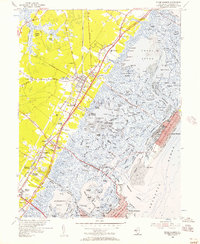
 1944 Rio Grande1944 Print · USGSCape May's western shore and interior settlements are captured during the peak of the Second World War. Researchers can trace the sprawling Wildwood US Naval Air Station and historic local communities such as Rio Grande, Nummytown, and Dias Creek.2 unique versions available
 - 1944 Map of Stone Harbor
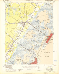 1944 Stone Harbor1944 Print · USGSCoastal Cape May County thrived as a rail-linked summer destination during the mid-1940s, balancing mainland hubs with growing seaside resorts. Researchers can trace the heritage of Whitesboro and Mayville or locate landmarks like the Stone Harbor CG Station and Bowers Municipal Fishing Pier.3 unique versions available
 - 1944 Map of Cape May
 1944 Cape May1944 Print · USGSCoastal New Jersey during the mid-forties shows the strategic importance of the peninsula during the war years. Local historians can trace the new Cape May Canal, the Cape May Coast Artillery Reserve, and the rails of the Reading Seashore Lines.2 unique versions available
 - 1946 Map of Wilmington, 1948 Print
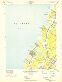
 1946 Wilmington1948 Print · USGSThe Delaware Valley and Jersey Shore emerge in this mid-century portrait of a region defined by river commerce and seaside growth. Genealogists and historians can trace the rail networks of the Pennsylvania Railroad, locate early airfields like Dover Airpark, and find river defenses at Fort Delaware.2 unique versions available
 - 1946 Map of Salisbury, 1948 Print
 1946 Salisbury1948 Print · USGSThe Delmarva Peninsula in the late nineteen-forties shows a landscape defined by its deep river arteries and emerging coastal defenses. Genealogists and historians can trace rail-connected towns like Federalsburg or locate maritime landmarks such as the Ocean City Seaplane Base and Fort Miles Military Reservation.4 unique versions available
 - 1947 Map of Salisbury, 1948 Print
 1947 Salisbury1948 Print · USGSThe Delmarva Peninsula in the late forties reveals a coastal landscape of maritime defense and growing seaside towns. Trace the post-war footprint of Salisbury, the strategic Fort Miles Military Reservation, and the Ocean City Seaplane Base.
 - 1948 Map of Salisbury, 1951 Print
 1948 Salisbury1951 Print · USGSThe Delmarva Peninsula in the late 1940s is shown here as a busy network of rail-towns and coastal outposts. Researchers can trace the legacy of the Pennsylvania Railroad through inland hubs like Georgetown or the maritime reaches of Crisfield and Cape May.
 - 1954 Map of Cape May, 1956 Print
 1954 Cape May1956 Print · USGSCape May and the Jersey Cape appear in the mid-fifties as a landscape of maritime defense and historic crossroads. Genealogists and historians can trace the foundations of Town Bank, locate the Cold Spring Ch, or study the grounds of the US Naval Res.4 unique versions available
 - 1955 Map of Wilmington
 1955 Wilmington1955 Print · USGSThe Delaware Valley and Jersey Shore are seen here during the mid-fifties era of rapid suburban expansion and highway development. You can trace the path of the New Jersey Turnpike, locate the Fort Dix Military Reservation, or explore the rail networks of the Pennsylvania Railroad.
 - 1955 Map of Wildwood, 1956 Print
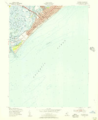 1955 Wildwood1956 Print · USGSThe Jersey Shore is in full swing during the mid-1950s, showing the iconic barrier island resorts and salt marshes before modern expansion. Researchers can trace the Pennsylvania-Reading Seashore Lines and the oceanfront Boardwalk through Wildwood and North Wildwood.4 unique versions available
 - 1955 Map of Stone Harbor, 1957 Print
 1955 Stone Harbor1957 Print · USGSThe Jersey Shore is captured mid-century as the Garden State Parkway began reshaping the coastal landscape. Trace the old rail lines and inland settlements like Whitesboro and Mayville, or explore the established grid of Stone Harbor.5 unique versions available
 - 1956 Map of Rio Grande, 1957 Print
 1956 Rio Grande1957 Print · USGSCape May's western bayfront communities are captured here in the mid-fifties as residential grids like Villas expanded alongside older marsh-side settlements. Genealogists and local researchers can trace the Pennsylvania-Reading Seashore Lines through Rio Grande and find family-named landmarks such as Sally Marshall Crossing and Nummytown.4 unique versions available
 - 1957 Map of Wilmington
 1957 Wilmington1957 Print · USGSThe mid-Atlantic coastal plain comes alive in the mid-fifties as the New Jersey Turnpike and Garden State Parkway redefine travel. Researchers can trace the rail-to-road transition and find landmarks like Ship John Shoal Light and the Fort Dix Military Reservation.2 unique versions available
Showing maps 1-25 of 55
Top cities near Lower Township
- Middle Township historical maps
- Upper Township historical maps
- Villas historical maps
- Maurice River Township historical maps
- Wildwood historical maps
- North Wildwood historical maps
See more
Top neighborhoods of Lower Township
- Shawcrest historical maps
- North Cape May historical maps
- Buck Landing historical maps
- Sunset Beach historical maps
- Cold Spring historical maps
- Tabernacle historical maps
See more
Frequently asked questions
- What are the different types of historical maps available for Lower Township?
- What is the oldest map of Lower Township?
- Where can I purchase historical maps of Lower Township for my home or office?
- Where can I download high-res historical maps of Lower Township?
- Are there historical topographic maps available for Lower Township?
- Is there historical aerial imagery available for Lower Township?
- Where are historical maps of Lower Township sourced from?