1900s (20th Century) Maps of Norburys Landing, Middle Township
Explore 12 historic maps of Norburys Landing from the 1900s (20th Century). These maps offer a rare glimpse into what life looked like during the 1900s — showing old roads, neighborhoods, homes, and landmarks that have changed or disappeared over time.
Whether you're researching your family's past, planning a metal detecting trip, or studying how Norburys Landing's landscape evolved across the 1900s, these high-resolution maps are a powerful tool for exploring the history of this region.
- Focus on a specific era: All maps on this page are from the 1900s, giving you a focused view of this time period.
- See what’s changed: Compare century-old streets, trails, and buildings to today's modern landscape using overlays and satellite layers.
- Research with precision: Use these maps for genealogy, historical research, land use analysis, or educational projects.
- View, download, or print: Maps are fully viewable online in high resolution, and can be downloaded or printed for your own records.
Start exploring Norburys Landing's history through authentic maps from the 1900s. This is your window into the past.
Norburys Landing, Middle Township maps
(12)- 1919 Map of Dennisville, 1921 Print
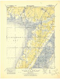 1919 Dennisville1921 Print · USGSCape May County's southern peninsula is documented here during the height of the coastal rail era, before modern development reshaped the shoreline. Genealogists and historians can trace the foundations of local commerce through sites like Bidwell Town Mill, Goshen Landing, and the many family-named stops along the Philadelphia & Reading R.R.
 - 1941 Map of Dennisville
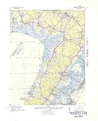 1941 Dennisville1941 Print · USGSCape May County's interior and coastal marshes are captured here in the early 1940s, from the bay-side landings to the Atlantic sounds. Trace the rail corridors of the Pennsylvania-Reading Seashore Lines through Dennisville and locate the State Prison Farm.2 unique versions available
 - 1944 Map of Rio Grande
 1944 Rio Grande1944 Print · USGSCape May's western shore and interior settlements are captured during the peak of the Second World War. Researchers can trace the sprawling Wildwood US Naval Air Station and historic local communities such as Rio Grande, Nummytown, and Dias Creek.2 unique versions available
 - 1946 Map of Wilmington, 1948 Print
 1946 Wilmington1948 Print · USGSThe Delaware Valley and Jersey Shore emerge in this mid-century portrait of a region defined by river commerce and seaside growth. Genealogists and historians can trace the rail networks of the Pennsylvania Railroad, locate early airfields like Dover Airpark, and find river defenses at Fort Delaware.2 unique versions available
 - 1955 Map of Wilmington
 1955 Wilmington1955 Print · USGSThe Delaware Valley and Jersey Shore are seen here during the mid-fifties era of rapid suburban expansion and highway development. You can trace the path of the New Jersey Turnpike, locate the Fort Dix Military Reservation, or explore the rail networks of the Pennsylvania Railroad.
 - 1956 Map of Rio Grande, 1957 Print
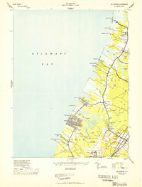
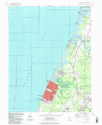
 1956 Rio Grande1957 Print · USGSCape May's western bayfront communities are captured here in the mid-fifties as residential grids like Villas expanded alongside older marsh-side settlements. Genealogists and local researchers can trace the Pennsylvania-Reading Seashore Lines through Rio Grande and find family-named landmarks such as Sally Marshall Crossing and Nummytown.4 unique versions available
 - 1957 Map of Wilmington
 1957 Wilmington1957 Print · USGSThe mid-Atlantic coastal plain comes alive in the mid-fifties as the New Jersey Turnpike and Garden State Parkway redefine travel. Researchers can trace the rail-to-road transition and find landmarks like Ship John Shoal Light and the Fort Dix Military Reservation.2 unique versions available
 - 1959 Map of Wilmington
 1959 Wilmington1959 Print · USGSThe Delaware Valley and Jersey Shore are seen here in the late fifties, during a period of massive suburban and highway expansion. Researchers can trace mid-century infrastructure like the N J Turnpike or locate coastal landmarks from Barnegat Bay to the Maurice River.3 unique versions available
 - 1966 Map of Wilmington, 1968 Print
 1966 Wilmington1968 Print · USGSThe Delaware Valley and Jersey Shore are seen here in the mid-1960s, documenting a landscape of dense industrial cities and emerging coastal resorts. Researchers can trace the sprawling rail networks of the Pennsylvania Railroad or locate landmarks like Fort Dix Military Reservation and Elk Neck State Park.4 unique versions available
 - 1972 Map of Wilmington, 1976 Print
 1972 Wilmington1976 Print · USGSThe Delaware Valley and Jersey Shore are seen here in the 1970s, showcasing the region's dense transport networks and vast state forests. Trace early coastal development near Atlantic City or locate rural landmarks like Mount Holly and Dover Air Force Base.2 unique versions available
 - 1984 Map of Atlantic City, 1985 Print
 1984 Atlantic City1985 Print · USGSThe Jersey Shore and Pine Barrens are captured here in the mid-eighties, showing the coastal transition from salt marsh to forest. Genealogists and historians can trace family locations from Estell Manor to North Wildwood or explore the vast bounds of the Belleplain State Forest.
 - 1994 Map of Rio Grande, 2000 Print
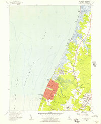
 1994 Rio Grande2000 Print · USGSCoastal Cape May County meets the Delaware Bay in the 1990s, where bayside communities and wildlife refuges dominate the shoreline. Researchers can trace local heritage through sites like Nummytown, the Fishing Creek Sch, and the residential blocks of Villas.
End of results
Showing maps 1-12 of 12
Top cities near Norburys Landing
- Lower Township historical maps
- Middle Township historical maps
- Upper Township historical maps
- Villas historical maps
- Maurice River Township historical maps
- Wildwood historical maps
See more
Frequently asked questions
- What are the different types of historical maps available for Norburys Landing?
- What is the oldest map of Norburys Landing?
- Where can I purchase historical maps of Norburys Landing for my home or office?
- Where can I download high-res historical maps of Norburys Landing?
- Are there historical topographic maps available for Norburys Landing?
- Is there historical aerial imagery available for Norburys Landing?
- Where are historical maps of Norburys Landing sourced from?