1950s Maps of Upper Township, New Jersey
Explore 9 historic maps of Upper Township from the 1950s. These maps offer a rare glimpse into what life looked like during the 1950s — showing old roads, neighborhoods, homes, and landmarks that have changed or disappeared over time.
Whether you're researching your family's past, planning a metal detecting trip, or studying how Upper Township's landscape evolved across the 1950s, these high-resolution maps are a powerful tool for exploring the history of this region.
- Focus on a specific era: All maps on this page are from the 1950s, giving you a focused view of this time period.
- See what’s changed: Compare century-old streets, trails, and buildings to today's modern landscape using overlays and satellite layers.
- Research with precision: Use these maps for genealogy, historical research, land use analysis, or educational projects.
- View, download, or print: Maps are fully viewable online in high resolution, and can be downloaded or printed for your own records.
Start exploring Upper Township's history through authentic maps from the 1950s. This is your window into the past.
Upper Township, NJ maps
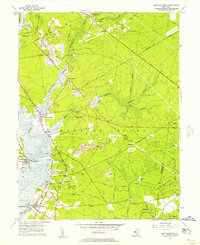
(9)- 1952 Map of Marmora, 1955 Print
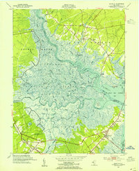 1952 Marmora1955 Print · USGSCoastal New Jersey during the early fifties reveals a landscape of tidal marshes and riverside landings at the confluence of two major rivers. Genealogists and local historians can trace family-named sites like Jeffers Landing, Scullville, and Palestine Ch along the winding banks of the Great Egg Harbor River.4 unique versions available
 - 1952 Map of Sea Isle City, 1955 Print
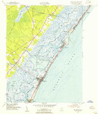 1952 Sea Isle City1955 Print · USGSCoastal Cape May County comes alive in the mid-fifties, showing the rail-connected barrier islands and dense inland swamps. Genealogists and local historians can locate early landmarks like Seaville Ch, the Coast Guard Station, and the Woodland Cem near Ocean View.6 unique versions available
 - 1952 Map of Ocean City, 1955 Print
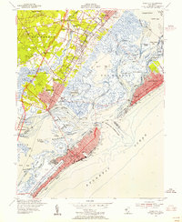 1952 Ocean City1955 Print · USGSThe Jersey Shore's barrier islands and mainland communities come alive in the early fifties, showing the interplay of coastal development and tidal marshland. Trace the rail routes of the Pennsylvania-Reading Seashore Lines or locate landmarks like the Municipal Pier and Friends Central Cem.4 unique versions available
 - 1955 Map of Wilmington
 1955 Wilmington1955 Print · USGSThe Delaware Valley and Jersey Shore are seen here during the mid-fifties era of rapid suburban expansion and highway development. You can trace the path of the New Jersey Turnpike, locate the Fort Dix Military Reservation, or explore the rail networks of the Pennsylvania Railroad.
 - 1956 Map of Tuckahoe, 1957 Print
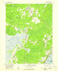
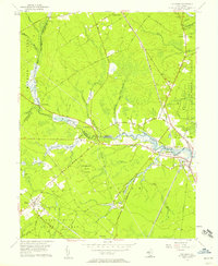 1956 Tuckahoe1957 Print · USGSThe coastal plains and river valleys of Cape May and Atlantic counties are captured here in the mid-fifties. Researchers can trace the legacy of family settlements and rural life at Steelmantown, Marshallville, and the Pennsylvania-Reading Seashore Lines.5 unique versions available
 - 1956 Map of Port Elizabeth, 1957 Print
 1956 Port Elizabeth1957 Print · USGSCoastal Cumberland County villages thrive along the river during the mid-fifties, supported by a mix of maritime trade and rail transport. Genealogists can trace family names at Leesburg Sch or locate historic industry at Fries Mill and Mauricetown Sta.4 unique versions available
 - 1957 Map of Wilmington
 1957 Wilmington1957 Print · USGSThe mid-Atlantic coastal plain comes alive in the mid-fifties as the New Jersey Turnpike and Garden State Parkway redefine travel. Researchers can trace the rail-to-road transition and find landmarks like Ship John Shoal Light and the Fort Dix Military Reservation.2 unique versions available
 - 1958 Map of Woodbine, 1959 Print
 1958 Woodbine1959 Print · USGSCape May County in the late fifties remains a landscape of dense wetlands and small rural hamlets connected by the Pennsylvania-Reading Seashore Lines. Trace the footprints of local history at Tiffereth Israel Cem, Ludlams Sch, and the State Colony.3 unique versions available
 - 1959 Map of Wilmington
 1959 Wilmington1959 Print · USGSThe Delaware Valley and Jersey Shore are seen here in the late fifties, during a period of massive suburban and highway expansion. Researchers can trace mid-century infrastructure like the N J Turnpike or locate coastal landmarks from Barnegat Bay to the Maurice River.3 unique versions available
End of results
Showing maps 1-9 of 9
Top cities near Upper Township
- Vineland historical maps
- Egg Harbor Township historical maps
- Galloway Township historical maps
- Millville historical maps
- Hamilton Township historical maps
- Lower Township historical maps
See more
Top neighborhoods of Upper Township
- Steelmantown historical maps
- Beesleys Point historical maps
- Middletown historical maps
- Petersburg historical maps
- Greenfield historical maps
- Palermo historical maps
See more
Frequently asked questions
- What are the different types of historical maps available for Upper Township?
- What is the oldest map of Upper Township?
- Where can I purchase historical maps of Upper Township for my home or office?
- Where can I download high-res historical maps of Upper Township?
- Are there historical topographic maps available for Upper Township?
- Is there historical aerial imagery available for Upper Township?
- Where are historical maps of Upper Township sourced from?