1990s Maps of Cumberland County, New Jersey
Explore 8 historic maps of Cumberland County from the 1990s. These maps offer a rare glimpse into what life looked like during the 1990s — showing old roads, neighborhoods, homes, and landmarks that have changed or disappeared over time.
Whether you're researching your family's past, planning a metal detecting trip, or studying how Cumberland County's landscape evolved across the 1990s, these high-resolution maps are a powerful tool for exploring the history of this region.
- Focus on a specific era: All maps on this page are from the 1990s, giving you a focused view of this time period.
- See what’s changed: Compare century-old streets, trails, and buildings to today's modern landscape using overlays and satellite layers.
- Research with precision: Use these maps for genealogy, historical research, land use analysis, or educational projects.
- View, download, or print: Maps are fully viewable online in high resolution, and can be downloaded or printed for your own records.
Start exploring Cumberland County's history through authentic maps from the 1990s. This is your window into the past.
Cumberland County, NJ maps
(8)- 1993 Map of Canton
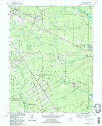
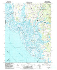 1993 Canton1993 Print · USGSCoastal Salem County comes into focus in the early nineties, showing a landscape defined by the vast marshlands of the Delaware Bay. Researchers can trace historic crossroads and tide-water landmarks from Harmersville down to Stow Creek Landing and the old milling site at Maskells Mill.
 - 1993 Map of Ben Davis Point
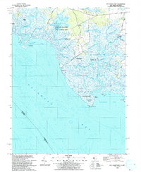 1993 Ben Davis Point1993 Print · USGSThe coastal reaches of Cumberland County are captured in the early nineties, where the marshy expanse of Back Neck meets the bay. Trace the isolated outposts at Husted Landing and Sea Breeze, or locate the Ben Davis Pt Light marking the shoreline.
 - 1993 Map of Bombay Hook Island
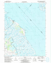 1993 Bombay Hook Island1993 Print · USGSThe Delaware Bay shoreline in the early 1990s is defined by vast coastal wetlands and managed wildlife habitats. Trace the land use patterns near Woodland Beach and the family-named roads leading to Whitehall and Whitehall Landing.
 - 1994 Map of Five Points, 1998 Print
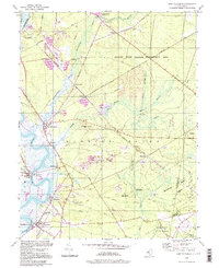
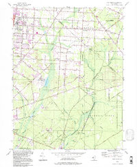 1994 Five Points1998 Print · USGSCumberland County during the late twentieth century reveals a landscape shaped by institutional growth and extensive pine barrens. Genealogists and historians can locate Vineland State School, trace the Central Railroad of New Jersey, and find old centers like New Italy.
 - 1994 Map of Port Elizabeth, 1998 Print
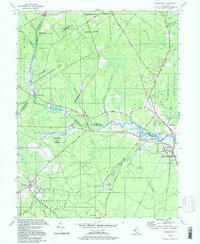
 1994 Port Elizabeth1998 Print · USGSThe Maurice River corridor near Port Elizabeth comes to life in the 1990s, showing a landscape shaped by river commerce and heavy conservation. Researchers can trace the layout of historic settlements like Dorchester, find the Leesburg Sch, and locate old industrial sites like Hoffmans Mill.
 - 1994 Map of Tuckahoe, 1998 Print
 1994 Tuckahoe1998 Print · USGSSouthern New Jersey in the 1990s reveals a landscape defined by the Tuckahoe River and vast state conservation lands. Genealogists and historians can trace old community ties through locations like Steelmantown, Marshallville, and the remote Hunters Mill.
 - 1994 Map of Dorothy, 1998 Print
 1994 Dorothy1998 Print · USGSAtlantic County at the end of the twentieth century remains a landscape of forest preserves and small crossroads towns. Genealogists and local historians can trace the foundations of Dorothy, Gigantic City, and Milmay, or locate family landmarks like Estell Manor Sch and St James Ch.
 - 1997 Map of Millville, 1998 Print
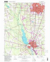 1997 Millville1998 Print · USGSCumberland County at the end of the twentieth century shows a dense network of glass-making history, diverse ethnic settlements, and the expansive Union Lake. Researchers can trace local roots through numerous sites including Hebrew Cem, Sacred Heart Cem, and the Ukranian Ch.
End of results
Showing maps 1-8 of 8
Top cities of Cumberland County
- Vineland historical maps
- Millville historical maps
- Bridgeton historical maps
- Maurice River Township historical maps
- Fairfield Township historical maps
- Commercial Township historical maps
See more
Frequently asked questions
- What are the different types of historical maps available for Cumberland County?
- What is the oldest map of Cumberland County?
- Where can I purchase historical maps of Cumberland County for my home or office?
- Where can I download high-res historical maps of Cumberland County?
- Are there historical topographic maps available for Cumberland County?
- Is there historical aerial imagery available for Cumberland County?
- Where are historical maps of Cumberland County sourced from?