1940s Maps of Maurice River Township, New Jersey
Explore 6 historic maps of Maurice River Township from the 1940s. These maps offer a rare glimpse into what life looked like during the 1940s — showing old roads, neighborhoods, homes, and landmarks that have changed or disappeared over time.
Whether you're researching your family's past, planning a metal detecting trip, or studying how Maurice River Township's landscape evolved across the 1940s, these high-resolution maps are a powerful tool for exploring the history of this region.
- Focus on a specific era: All maps on this page are from the 1940s, giving you a focused view of this time period.
- See what’s changed: Compare century-old streets, trails, and buildings to today's modern landscape using overlays and satellite layers.
- Research with precision: Use these maps for genealogy, historical research, land use analysis, or educational projects.
- View, download, or print: Maps are fully viewable online in high resolution, and can be downloaded or printed for your own records.
Start exploring Maurice River Township's history through authentic maps from the 1940s. This is your window into the past.
Maurice River Township, NJ maps
(6)- 1941 Map of Dennisville
 1941 Dennisville1941 Print · USGSCape May County's interior and coastal marshes are captured here in the early 1940s, from the bay-side landings to the Atlantic sounds. Trace the rail corridors of the Pennsylvania-Reading Seashore Lines through Dennisville and locate the State Prison Farm.2 unique versions available
 - 1941 Map of Port Norris
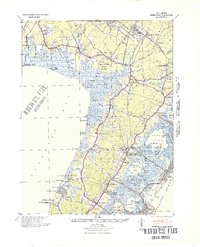
 1941 Port Norris1941 Print · USGSCumberland County's maritime heart is captured here during the early 1940s, as the oyster industry centered on Bivalve and Port Norris reached its mid-century peak. Researchers can trace the Reading Seashore Lines to the coast or locate remote outposts like Fortescue and Matts Landing.
 - 1941 Map of Tuckahoe
 1941 Tuckahoe1941 Print · USGSCoastal New Jersey at the start of the 1940s reveals a landscape defined by sand mining and a dense network of steam and electric rail. Genealogists and historians can trace the paths of the Pennsylvania Reading Seashore Lines through rural stops like Port Elizabeth, Mizpah, and Walkers Forge.
 - 1942 Map of Bridgeton
 1942 Bridgeton1942 Print · USGSCumberland County during the early war years shows a landscape of busy glass-making towns and rural farming hamlets connected by an intricate rail network. Researchers can trace the lines of the Central Railroad of New Jersey to old mills and landings like Shaws Mill and Tindells Landing.
 - 1946 Map of Wilmington, 1948 Print
 1946 Wilmington1948 Print · USGSThe Delaware Valley and Jersey Shore emerge in this mid-century portrait of a region defined by river commerce and seaside growth. Genealogists and historians can trace the rail networks of the Pennsylvania Railroad, locate early airfields like Dover Airpark, and find river defenses at Fort Delaware.2 unique versions available
 - 1948 Map of Bridgeton
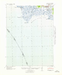
 1948 Bridgeton1948 Print · USGSCumberland County at the close of the 1940s reveals a landscape defined by tidewater rivers and a maturing rail network. Researchers can trace the heritage of rural settlements like Gouldtown and Rosenhayn or locate historic industry at Lummis Mill and Mauricetown Station.3 unique versions available
End of results
Showing maps 1-6 of 6
Top cities near Maurice River Township
- Vineland historical maps
- Egg Harbor Township historical maps
- Millville historical maps
- Hamilton Township historical maps
- Middle Township historical maps
- Upper Township historical maps
See more
Top neighborhoods of Maurice River Township
- Dorchester historical maps
- Hoffmans Mill historical maps
- Jones Mill historical maps
- Manumuskin historical maps
- Ormond historical maps
- Port Elizabeth historical maps
See more
Frequently asked questions
- What are the different types of historical maps available for Maurice River Township?
- What is the oldest map of Maurice River Township?
- Where can I purchase historical maps of Maurice River Township for my home or office?
- Where can I download high-res historical maps of Maurice River Township?
- Are there historical topographic maps available for Maurice River Township?
- Is there historical aerial imagery available for Maurice River Township?
- Where are historical maps of Maurice River Township sourced from?