1990s Maps of Essex County, New Jersey
Explore 6 historic maps of Essex County from the 1990s. These maps offer a rare glimpse into what life looked like during the 1990s — showing old roads, neighborhoods, homes, and landmarks that have changed or disappeared over time.
Whether you're researching your family's past, planning a metal detecting trip, or studying how Essex County's landscape evolved across the 1990s, these high-resolution maps are a powerful tool for exploring the history of this region.
- Focus on a specific era: All maps on this page are from the 1990s, giving you a focused view of this time period.
- See what’s changed: Compare century-old streets, trails, and buildings to today's modern landscape using overlays and satellite layers.
- Research with precision: Use these maps for genealogy, historical research, land use analysis, or educational projects.
- View, download, or print: Maps are fully viewable online in high resolution, and can be downloaded or printed for your own records.
Start exploring Essex County's history through authentic maps from the 1990s. This is your window into the past.
Essex County, NJ maps
(6)- 1995 Map of Pompton Plains, 1998 Print
 1995 Pompton Plains1998 Print · USGSThe northern New Jersey suburban corridor and the Great Piece Meadows are captured here in the mid-1990s. Researchers can trace family history through sites like Mount Rest Cem or locate regional landmarks such as the Lincoln Park Airport and Pequannock Valley Sch.
 - 1995 Map of Caldwell, 1998 Print
 1995 Caldwell1998 Print · USGSThe Essex and Morris county borderlands are shown here in the 1990s as suburban growth surrounds the Passaic River wetlands. Researchers can trace local institutions like Caldwell College for Women, the Kessler Institute, and the Gate of Heaven Cemetery.
 - 1995 Map of Roselle, 1998 Print
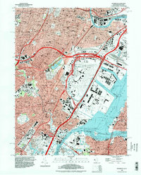
 1995 Roselle1998 Print · USGSIn the mid-1990s, the dense residential corridors of Union and Essex counties remained anchored by historic transit lines and extensive parklands. Genealogists and local historians can trace family locations near landmarks like Seton Hall University, Fairview Cemetery, and the Rahway Valley RR.
 - 1995 Map of Elizabeth, 1998 Print
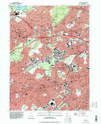
 1995 Elizabeth1998 Print · USGSNorthern New Jersey and Staten Island show their dense urban and industrial character in the 1990s. Trace local history through institutions like Seton Hall Univ or find family landmarks in Evergreen Cemetery and Rose Hill Cemetery.
 - 1995 Map of Paterson, 1999 Print
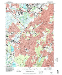
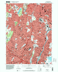
 1995 Paterson1999 Print · USGSThe industrial and suburban landscape of Northern New Jersey is shown here during the late 1990s as it centers on the Passaic River valley. Researchers can trace historic institutions and neighborhoods from William Paterson University to the Holy Sepulchre Cemetery and the Erie Railroad lines.
 - 1995 Map of Orange, 2000 Print
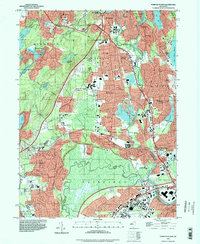
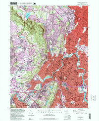
 1995 Orange2000 Print · USGSNortheastern New Jersey in the mid-nineties shows a complex network of established townships and intensive rail-and-road infrastructure. Researchers can trace family history through numerous landmarks like the Thomas A Edison Nat Hist Site, Mt Hebron Cemetery, and Overbrook Hospital.
End of results
Showing maps 1-6 of 6
Top cities of Essex County
- Newark historical maps
- East Orange historical maps
- Irvington historical maps
- Bloomfield historical maps
- West Orange historical maps
- Montclair historical maps
See more
Frequently asked questions
- What are the different types of historical maps available for Essex County?
- What is the oldest map of Essex County?
- Where can I purchase historical maps of Essex County for my home or office?
- Where can I download high-res historical maps of Essex County?
- Are there historical topographic maps available for Essex County?
- Is there historical aerial imagery available for Essex County?
- Where are historical maps of Essex County sourced from?