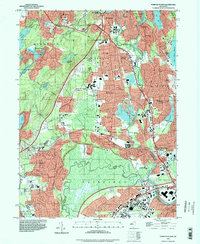
1995 Map of Pompton Plains
USGS Topo · Published 1998About this map
Great Piece Meadows dominates the southern landscape of this northern New Jersey corridor, where the Passaic River meets the Pequannock River and Ramapo River. This 1990s record of the area illustrates the dense suburbanization and transportation networks surrounding Pompton Plains, Pequannock, and Lincoln Park. Local history and genealogy are preserved through numerous local landmarks, including Mount Calvary Cem in Butler, Mount Rest Cem, and the Clinton Cem further south.
Find a feature on this map
95 named features on this map. Tap any name to fly to it.
Don’t see what you’re looking for? This feature index may not catch every label — zoom into the map to look around manually.
Map Details
Editions of this 1995 Pompton Plains Map
This is the sole edition of this map. No revisions or reprints were ever made.
Other maps of this area

1888 · Morristown
USGS Topo · 1:62,500

1888 · Paterson
USGS Topo · 1:62,500

1891 · Greenwood Lake
USGS Topo · 1:62,500

1891 · Ramapo
USGS Topo · 1:62,500

1892 · Paterson
USGS Topo · 1:62,500

1893 · Greenwood Lake
USGS Topo · 1:62,500

1893 · Ramapo
USGS Topo · 1:62,500

1894 · Morristown
USGS Topo · 1:62,500

1898 · Morristown
USGS Topo · 1:62,500

1898 · Paterson
USGS Topo · 1:62,500