
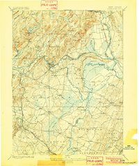
1898 Map of Morristown
USGS Topo · Published 1898About this map
The Passaic River and Rockaway River define the hydraulic landscape of Morris County in the late nineteenth century. This map documents a critical era of transport infrastructure, where the industrial legacy of the Morris Canal and its Morris Canal Feeder intersects with a growing rail network. Large industrial and mining centers like Hibernia and Boonton appear alongside agricultural hubs such as Parsippany and Whippany. The presence of numerous crossings, including Swinefield Bridge, Cooks Bridge, and Columbia Bridge, illustrates the established travel routes connecting the townships of Hanover, Caldwell, and Chatham. To the north, the terrain transitions into the steep elevations of Waughaw Mt. and the waters of Splitrock Pond, providing a clear view of the area's natural drainage patterns before the onset of modern suburbanization.
Find a feature on this map
91 named features on this map. Tap any name to fly to it.
Don’t see what you’re looking for? This feature index may not catch every label — zoom into the map to look around manually.
Map Details
Editions of this 1898 Morristown Map
2 editions found
Other maps of this area

1888 · Franklin
USGS Topo · 1:62,500

1888 · Plainfield
USGS Topo · 1:62,500

1888 · Morristown
USGS Topo · 1:62,500

1888 · Lake Hopatcong
USGS Topo · 1:62,500

1888 · Paterson
USGS Topo · 1:62,500

1891 · Somerville
USGS Topo · 1:62,500

1891 · Greenwood Lake
USGS Topo · 1:62,500

1891 · Ramapo
USGS Topo · 1:62,500

1892 · Paterson
USGS Topo · 1:62,500

1893 · Plainfield
USGS Topo · 1:62,500