1990s Maps of Harrison Township, New Jersey
Explore 3 historic maps of Harrison Township from the 1990s. These maps offer a rare glimpse into what life looked like during the 1990s — showing old roads, neighborhoods, homes, and landmarks that have changed or disappeared over time.
Whether you're researching your family's past, planning a metal detecting trip, or studying how Harrison Township's landscape evolved across the 1990s, these high-resolution maps are a powerful tool for exploring the history of this region.
- Focus on a specific era: All maps on this page are from the 1990s, giving you a focused view of this time period.
- See what’s changed: Compare century-old streets, trails, and buildings to today's modern landscape using overlays and satellite layers.
- Research with precision: Use these maps for genealogy, historical research, land use analysis, or educational projects.
- View, download, or print: Maps are fully viewable online in high resolution, and can be downloaded or printed for your own records.
Start exploring Harrison Township's history through authentic maps from the 1990s. This is your window into the past.
Harrison Township, NJ maps
(3)- 1995 Map of Woodbury, 1999 Print
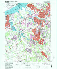 1995 Woodbury1999 Print · USGSGloucester County at the close of the twentieth century shows a landscape of established suburban boroughs and major riverfront industry. You can trace family roots through numerous local landmarks, including Eglington Cemetery, the County Institution, and Gateway Regional High School.
 - 1995 Map of Pitman West, 1999 Print
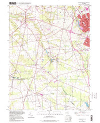 1995 Pitman West1999 Print · USGSGloucester County in the mid-nineties shows a mix of growing suburban centers and traditional rural crossroads. Researchers can trace historic family locations near Wrights Mill and Jessups Mill or locate old community landmarks like Mt Calvary Ch and Rodgers Sch.
 - 1995 Map of Bridgeport, 1999 Print
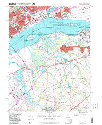 1995 Bridgeport1999 Print · USGSThe Delaware River waterfront near the turn of the millennium shows a landscape defined by heavy industry and critical transportation links. Researchers can trace historic local sites like Solomons Graveyard, the Seaplane Base, and the Bridgeport Airport during a period of significant regional change.
End of results
Showing maps 1-3 of 3
Top cities near Harrison Township
- Philadelphia historical maps
- Upper Darby historical maps
- Camden historical maps
- Cherry Hill Township historical maps
- Vineland historical maps
- Washington Township historical maps
See more
Top neighborhoods of Harrison Township
Frequently asked questions
- What are the different types of historical maps available for Harrison Township?
- What is the oldest map of Harrison Township?
- Where can I purchase historical maps of Harrison Township for my home or office?
- Where can I download high-res historical maps of Harrison Township?
- Are there historical topographic maps available for Harrison Township?
- Is there historical aerial imagery available for Harrison Township?
- Where are historical maps of Harrison Township sourced from?