Old Maps of Hunterdon County, New Jersey
Explore 177 old maps of Hunterdon County, spanning from 1888 to today. These high-resolution historic maps reveal how streets, neighborhoods, landmarks, and natural features evolved over time — perfect for genealogy, metal detecting, research, and local history exploration.
What you can do with these maps:
- See how Hunterdon County changed over time: Compare historical maps to modern-day views to trace roads, homesites, rail lines & more.
- View detailed metadata: Each map includes creators, publishers, year, scale, and archive source.
- Overlay maps with satellite & LiDAR: Visualize the past alongside modern tools to explore terrain & human change.
- Trusted historical sources: Maps sourced from the USGS, Library of Congress, and other archives.
- Access maps your way: View online, download high-res files, or order prints for personal or research use.
Start exploring old maps of Hunterdon County to uncover forgotten places, hidden landmarks, and the deep history beneath your feet.
Hunterdon County, NJ maps
(177)- 1888 Map of Hackettstown
 1888 Hackettstown1888 Print · USGSNorthwestern New Jersey in the late nineteenth century was a hub of transit and industry defined by the Morris Canal and competing rail lines. Genealogists and historians can trace old homesteads and industrial sites near Oxford Furnace, Waterloo, and Hackettstown.
 - 1888 Map of Princeton
 1888 Princeton1888 Print · USGSCentral New Jersey in the late nineteenth century is defined here by its critical canal and rail corridors connecting thriving agricultural villages. Genealogists and historians can trace family-named sites and early junctions like Grover's Mill, Griggstown, and the rail hub at Monmouth Junction.
 - 1890 Map of Easton
 1890 Easton1890 Print · USGSThe Delaware River valley thrived as a transport hub during the 1890s, where three major canals and multiple railroads met at the Pennsylvania-New Jersey border. Genealogists and industrial historians can trace the paths of the Morris Canal, the works at Durham Furnace, and the strategic Musconetcong Tunnel.
 - 1890 Map of High Bridge
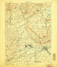
 1890 High Bridge1890 Print · USGSHunterdon and Morris counties at the close of the nineteenth century are defined by their complex rail networks and dramatic ridges. Genealogists and historians can trace the early layouts of High Bridge, Clinton, and the settlements surrounding the distinct curve of Cushetunk Mountain.2 unique versions available
 - 1890 Map of Lambertville
 1890 Lambertville1890 Print · USGSThe Delaware River valley thrived at the end of the nineteenth century as a hub for both canal and rail transport. Genealogists can trace family names and legacy sites near Lambertville, Washington's Crossing, and the junctions at Ringoes.
 - 1890 Map of Doylestown
 1890 Doylestown1890 Print · USGSBucks County in the late nineteenth century is captured here as a landscape of established mill towns and farming crossroads. Local historians can trace early rail routes like the Doylestown Branch and discover forgotten names such as New Galena, Griers Corner, and Hinkletown.
 - 1891 Map of Somerville
 1891 Somerville1891 Print · USGSSomerset County was a bustling corridor of industry and rail commerce at the close of the nineteenth century. Genealogists and local historians can trace family roots through specific stops like North Branch Depot or explore the early infrastructure of Bound Brook and the Water Power Cos Raceway.2 unique versions available
 - 1891 Map of Easton
 1891 Easton1891 Print · USGSThe Delaware River valley thrived as a corridor of heavy industry and transit in the 1890s. Trace the path of historic waterways and early rail lines, including the Morris Canal, the ironworks at Durham Furnace, and rural crossroads like Still Valley.8 unique versions available
 - 1891 Map of Lambertville
 1891 Lambertville1891 Print · USGSThe Delaware River valley in the late 1880s is captured here at the height of the canal and rail era. Genealogists and historians can trace the early footprints of Lambertville, the course of the Delaware and Raritan Canal Feeder, and crossroads like Ringoes.
 - 1891 Map of Doylestown
 1891 Doylestown1891 Print · USGSBucks County and the Delaware River valley are captured in the late Victorian era as the region's agricultural and industrial patterns were firmly established. Genealogists and historians can trace old homestead locations near Kellers Church, identify stops along the Penna Railroad, and find riverside hamlets like Raven Rock and Tumble.11 unique versions available
 - 1893 Map of Somerville
 1893 Somerville1893 Print · USGSSomerset County in the late nineteenth century is a hub of rail-driven commerce and riverfront industry. Local historians can trace the early footprints of Bernardsville and Basking Ridge or locate vanished landmarks like Burnt Mill and North Branch Depot.
 - 1894 Map of Hackettstown
 1894 Hackettstown1894 Print · USGSNorthwestern New Jersey is captured here in the late nineteenth century as a hub of iron production and mountain railroading. Researchers can pinpoint early industrial sites like Oxford Furnace or trace the routes of the Morris and Essex Railroad and Lehigh and Hudson River Railroad.
 - 1894 Map of Princeton
 1894 Princeton1894 Print · USGSCentral New Jersey is captured here in the late nineteenth century as its river-and-canal economy transitioned to a powerhouse of rail travel. Genealogists and historians can trace the early footprints of Princeton, the industrial Delaware and Raritan Canal, and rural stops like Grover Mill.2 unique versions available
 - 1894 Map of Lambertville
 1894 Lambertville1894 Print · USGSThe Delaware River valley was a thriving hub of 19th-century commerce, where twin canals and the Belvidere Division railroad powered local industry. Researchers can trace ancestral lands through numerous family-named landmarks like Muirheads and Larison Corner, or locate the exact 1890s footprints of Lambertville and Hopewell.4 unique versions available
 - 1898 Map of Hackettstown
 1898 Hackettstown1898 Print · USGSNorthwest New Jersey at the turn of the century is defined by its deep river valleys and the early railroads that pierced its ridge lines. Genealogists and historians can trace the foundations of Hackettstown or locate long-standing landmarks like Swayze Mills and Saxton Falls.2 unique versions available
 - 1898 Map of High Bridge
 1898 High Bridge1898 Print · USGSHunterdon County is mapped in the late nineteenth century as a vital transportation corridor defined by the Cushetunk Mountain range. Genealogists and historians can trace the exact rail routes and rural hamlets of the era, from High Bridge and Glen Gardner to the Lehigh Valley Railroad.2 unique versions available
 - 1898 Map of Somerville
 1898 Somerville1898 Print · USGSSomerset County in the late nineteenth century is a landscape of established river towns and critical rail junctions. Genealogists and historians can trace the growth of Somerville, locate small communities like Pluckemin, or follow the Water Power Cos Raceway near Raritan.2 unique versions available
 - 1900 Map of Raritan
 1900 Raritan1900 Print · USGSNorth Jersey in the late nineteenth century was a complex web of mountain ridges and vital rail corridors. Researchers can trace ancestral routes through old junctions like High Bridge, industrial sites at Mine Hill, and the shores of Lake Hopatcong.
 - 1905 Map of Raritan
 1905 Raritan1905 Print · USGSNorthern New Jersey's ridges and valleys are meticulously detailed here at the turn of the century. You can trace the complex rail networks of the Lehigh Valley R.R. and locate family landmarks from Swayze Mills to the Powder Depot near Picatinny Peak.2 unique versions available
 - 1905 Map of Somerville
 1905 Somerville1905 Print · USGSCentral New Jersey at the start of the twentieth century shows a landscape shaped by the Raritan River and early rail expansion. Researchers can trace the Delaware and Raritan Canal, locate landmarks like Chimney Rock, and find old centers like Pluckemin and Bernardsville.3 unique versions available
 - 1905 Map of High Bridge
 1905 High Bridge1905 Print · USGSHunterdon County at the opening of the twentieth century was a vital junction for New Jersey’s industrial rail lines and river-powered settlements. Researchers can trace the legacy tracks of the Central Railroad of New Jersey and locate early communities like High Bridge, Clinton, and Annandale.4 unique versions available
 - 1905 Map of Hackettstown
 1905 Hackettstown1905 Print · USGSWarren and Morris Counties at the turn of the century show a landscape defined by industrial transport and river valleys. Researchers can trace the historic Morris Canal and the complex rail networks serving towns like Hackettstown, Vienna, and Oxford.5 unique versions available
 - 1906 Map of Lambertville
 1906 Lambertville1906 Print · USGSThe Delaware River valley in the early 1900s is shown in transition, where water-borne trade meets the expanding rail network. Genealogists and historians can trace family-named corners like Vanlieu Corners and Marshalls Corner alongside the Delaware and Raritan Canal.6 unique versions available
 - 1906 Map of Princeton
 1906 Princeton1906 Print · USGSNew Jersey’s educational and transportation corridors are captured here in the early twentieth century, showing a landscape defined by canals and competing rail lines. Genealogists can trace family roots through settlements like Princeton, Rocky Hill, and Plainsboro.4 unique versions available
 - 1907 Map of Trenton
 1907 Trenton1907 Print · USGSThe Delaware River valley hums with turn-of-the-century industry and transport as river canals and railroads converge between New Jersey and Pennsylvania. Genealogists and local historians can trace the footprint of the George School, find early post offices like Holland PO, or locate old mill sites such as Blackwells Mills.4 unique versions available
Showing maps 1-25 of 177
Top cities of Hunterdon County
- Raritan Township historical maps
- Readington Township historical maps
- Union historical maps
- Holland Township historical maps
- Flemington historical maps
- East Amwell Township historical maps
See more
Frequently asked questions
- What are the different types of historical maps available for Hunterdon County?
- What is the oldest map of Hunterdon County?
- Where can I purchase historical maps of Hunterdon County for my home or office?
- Where can I download high-res historical maps of Hunterdon County?
- Are there historical topographic maps available for Hunterdon County?
- Is there historical aerial imagery available for Hunterdon County?
- Where are historical maps of Hunterdon County sourced from?