1950s Maps of South Brunswick, New Jersey
Explore 6 historic maps of South Brunswick from the 1950s. These maps offer a rare glimpse into what life looked like during the 1950s — showing old roads, neighborhoods, homes, and landmarks that have changed or disappeared over time.
Whether you're researching your family's past, planning a metal detecting trip, or studying how South Brunswick's landscape evolved across the 1950s, these high-resolution maps are a powerful tool for exploring the history of this region.
- Focus on a specific era: All maps on this page are from the 1950s, giving you a focused view of this time period.
- See what’s changed: Compare century-old streets, trails, and buildings to today's modern landscape using overlays and satellite layers.
- Research with precision: Use these maps for genealogy, historical research, land use analysis, or educational projects.
- View, download, or print: Maps are fully viewable online in high resolution, and can be downloaded or printed for your own records.
Start exploring South Brunswick's history through authentic maps from the 1950s. This is your window into the past.
South Brunswick, NJ maps
(6)- 1953 Map of Jamesburg, 1955 Print
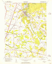 1953 Jamesburg1955 Print · USGSMid-century Middlesex County is captured just as the industrial corridors of the Pennsylvania railroad met the rising influence of the New Jersey Turnpike. Researchers can trace rural lineages through St James Cem and Township Sch No 2 or explore the footprint of the State Home for Boys.5 unique versions available
 - 1954 Map of New Brunswick, 1956 Print
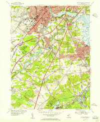 1954 New Brunswick1956 Print · USGSMid-century Middlesex County is captured during a transformative era of suburban growth and institutional expansion. Genealogists and local historians can trace family plots in Elmwood Cemetery or locate old schoolhouses like Weber Sch and McGinnis Sch.5 unique versions available
 - 1954 Map of Hightstown, 1956 Print
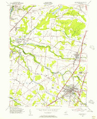 1954 Hightstown1956 Print · USGSIn the mid-1950s, the area between Princeton and HIGHTSTOWN remained a patchwork of small settlements and institutional campuses. Researchers can trace the layout of early communities at Grovers Mills and Princeton Junction or find local landmarks like Peddie Prep Sch and Mt Zion Ch.5 unique versions available
 - 1954 Map of Monmouth Junction, 1956 Print
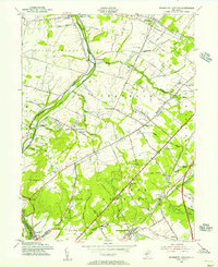 1954 Monmouth Junction1956 Print · USGSCentral New Jersey in the mid-fifties reveals a landscape shaped by the Delaware and Raritan Canal and the Pennsylvania Railroad. Researchers can trace the legacy of the Revolution at Washington Headquarters or locate family plots in Cedar Hill Cem and Elmwood Cem.6 unique versions available
 - 1956 Map of Newark
 1956 Newark1956 Print · USGSThe industrial heart of the Mid-Atlantic is captured here at the dawn of the highway era, tracing the dense corridors between Newark and Philadelphia. Genealogists and local historians can map the rail networks of the Reading RR or locate mid-century military life at Fort Dix Military Reservation.2 unique versions available
 - 1957 Map of Newark
 1957 Newark1957 Print · USGSThe industrial and military heart of the Mid-Atlantic is mapped during its post-war suburban boom. Genealogists and historians can trace the intricate rail corridors of the Reading Railroad and locate key landmarks from Princeton University to Fort Hancock.
End of results
Showing maps 1-6 of 6
Top cities near South Brunswick
- Edison historical maps
- Woodbridge Township historical maps
- Hamilton Township historical maps
- Trenton historical maps
- Franklin Township historical maps
- Old Bridge Township historical maps
See more
Top neighborhoods of South Brunswick
- Franklin Park historical maps
- Kendall Park historical maps
- Ten Mile Run historical maps
- Deans historical maps
- Kingston historical maps
- Fresh Ponds historical maps
See more
Frequently asked questions
- What are the different types of historical maps available for South Brunswick?
- What is the oldest map of South Brunswick?
- Where can I purchase historical maps of South Brunswick for my home or office?
- Where can I download high-res historical maps of South Brunswick?
- Are there historical topographic maps available for South Brunswick?
- Is there historical aerial imagery available for South Brunswick?
- Where are historical maps of South Brunswick sourced from?