1990s Maps of Sea Girt, New Jersey
Explore 2 historic maps of Sea Girt from the 1990s. These maps offer a rare glimpse into what life looked like during the 1990s — showing old roads, neighborhoods, homes, and landmarks that have changed or disappeared over time.
Whether you're researching your family's past, planning a metal detecting trip, or studying how Sea Girt's landscape evolved across the 1990s, these high-resolution maps are a powerful tool for exploring the history of this region.
- Focus on a specific era: All maps on this page are from the 1990s, giving you a focused view of this time period.
- See what’s changed: Compare century-old streets, trails, and buildings to today's modern landscape using overlays and satellite layers.
- Research with precision: Use these maps for genealogy, historical research, land use analysis, or educational projects.
- View, download, or print: Maps are fully viewable online in high resolution, and can be downloaded or printed for your own records.
Start exploring Sea Girt's history through authentic maps from the 1990s. This is your window into the past.
Sea Girt, NJ maps
(2)- 1995 Map of Point Pleasant, 2000 Print
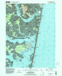 1995 Point Pleasant2000 Print · USGSThe Barnegat Bay shoreline and the Manasquan River inlets are captured here in the mid-nineties during a period of established coastal growth. Researchers can trace local landmarks like Bay Head Junction, White Lawn Cem, and the Winter Yacht Basin.
 - 1995 Map of Asbury Park, 2001 Print
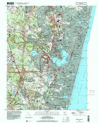 1995 Asbury Park2001 Print · USGSThe New Jersey shore at the close of the twentieth century shows a complex landscape of coastal boroughs and military installations. Genealogists can trace family footprints through sites like Algers Mills, Shafto Corners, and the Monmouth Mem Park (Cem).
End of results
Showing maps 1-2 of 2
Top cities near Sea Girt
- Toms River historical maps
- Lakewood Township historical maps
- Brick Township historical maps
- Middletown Township historical maps
- Old Bridge Township historical maps
- Howell Township historical maps
See more
Frequently asked questions
- What are the different types of historical maps available for Sea Girt?
- What is the oldest map of Sea Girt?
- Where can I purchase historical maps of Sea Girt for my home or office?
- Where can I download high-res historical maps of Sea Girt?
- Are there historical topographic maps available for Sea Girt?
- Is there historical aerial imagery available for Sea Girt?
- Where are historical maps of Sea Girt sourced from?