1940s Maps of Morris County, New Jersey
Explore 24 historic maps of Morris County from the 1940s. These maps offer a rare glimpse into what life looked like during the 1940s — showing old roads, neighborhoods, homes, and landmarks that have changed or disappeared over time.
Whether you're researching your family's past, planning a metal detecting trip, or studying how Morris County's landscape evolved across the 1940s, these high-resolution maps are a powerful tool for exploring the history of this region.
- Focus on a specific era: All maps on this page are from the 1940s, giving you a focused view of this time period.
- See what’s changed: Compare century-old streets, trails, and buildings to today's modern landscape using overlays and satellite layers.
- Research with precision: Use these maps for genealogy, historical research, land use analysis, or educational projects.
- View, download, or print: Maps are fully viewable online in high resolution, and can be downloaded or printed for your own records.
Start exploring Morris County's history through authentic maps from the 1940s. This is your window into the past.
Morris County, NJ maps
(24)- 1942 Map of Passaic
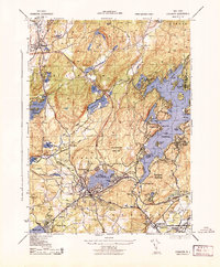
 1942 Passaic1942 Print · USGSNorthern New Jersey and New York harbor appear in detail at the start of the war, showing a landscape of burgeoning suburbs and vital industry. Trace family roots and local history across the Passaic River valley, from Paterson to the Watchung Mountains.
 - 1943 Map of Stanhope
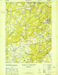
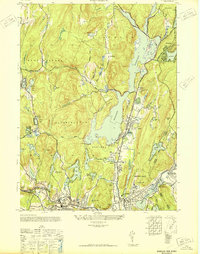
 1943 Stanhope1943 Print · USGSMid-century Sussex and Morris County life is centered here on the busy rail and water corridors of the highlands. Researchers can trace the path of the Morris Canal, locate the Hercules Powder Co works, and explore lakefront landmarks like Bertrand Island.
 - 1943 Map of Franklin Furnace
 1943 Franklin Furnace1943 Print · USGSMid-century Sussex County is defined here by its deep mining roots and mountain reservoirs. Trace the industrial landscape of Franklin and Ogdensburg through landmarks like the N J Zinc Co, the Stockholm School, and the Lehigh and Hudson River.
 - 1943 Map of Newfoundland
 1943 Newfoundland1943 Print · USGSThe Pequannock River valley and its surrounding ridges are captured here during the Second World War. Researchers can trace the New York Susquehanna and Western rail line through Newfoundland or locate landmarks like the Fire House and West Milford School.
 - 1943 Map of Hackettstown
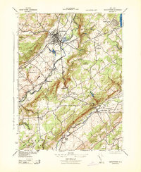 1943 Hackettstown1943 Print · USGSNew Jersey's northwestern hills and valleys come alive in this wartime survey, showing the industry and landscapes of the Musconetcong and Raritan watersheds. Genealogists and historians can trace rail lines to the N J Hosiery Mill, the State Fish Hatchery, and rural centers like Drakestown and Springtown.
 - 1943 Map of Gladstone
 1943 Gladstone1943 Print · USGSSomerset and Morris counties are captured here during the early 1940s, showing a landscape of deep-rooted mining history and river-valley farming. Genealogists can locate family landmarks like St Bernards School, the DL & W RR corridor, and the sites of the Wortman Mine and Bartles Mine.
 - 1943 Map of Washington
 1943 Washington1943 Print · USGSWarren County at the height of the second World War reveals a busy landscape of industry and rail. Genealogists can trace family names at the Pequest Union Cemetery or find historic workplaces like Oxford Furnace and the Magnetite Mine.
 - 1943 Map of Chester
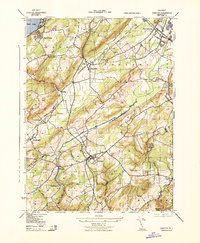 1943 Chester1943 Print · USGSMorris County was a landscape of rail-connected hamlets and river valleys during the early years of the war. Researchers can trace historic local life through sites like Hacklebarney State Park, the Flanders School, and the junction of the High Bridge Branch.
 - 1943 Map of Califon
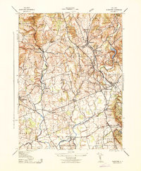
 1943 Califon1943 Print · USGSHunterdon County during the early 1940s maintains its agrarian character along the winding South Branch Raritan River. Genealogists and historians can trace the foundations of local life at New Germantown, the Burrill Mine, and the N. J. State Reformatory.
 - 1943 Map of Tranquility
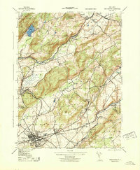
 1943 Tranquility1943 Print · USGSWarren and Sussex Counties were defined by quiet hamlets and intersecting rail lines in the mid-forties, long before the modern interstate era. Researchers can trace historic family landmarks and rural infrastructure from the Quaker Church to the Delaware Lackawanna and Western RR and the old settlement of Waterloo.
 - 1943 Map of Pompton Plains, 1947 Print
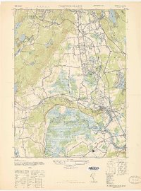 1943 Pompton Plains1947 Print · USGSIn the New Jersey valley of the Passaic, these mid-century Morris County communities are shown just before postwar suburbanization. Researchers can trace the junction of the Erie RR and Lackawanna RR or locate early airfields like North Jersey Airport and Murchia Airport.
 - 1943 Map of Roselle, 1947 Print
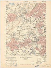
 1943 Roselle1947 Print · USGSUnion County's industrial and commuter corridors are shown here at the height of the war years. Genealogists and rail historians can trace the complex junctions at Cranford Junction and locate family plots in Hazelwood Cem or Graceland Mem Park Cem.
 - 1944 Map of Newark, 1971 Print
 1944 Newark1971 Print · USGSThe industrial corridor from Philadelphia to New York was in a period of massive transition during the mid-forties. Genealogists and researchers can trace the rail lines of the Lehigh Valley RR, locate military installations like Picatinny Arsenal, and explore the early sprawl near Levittown.5 unique versions available
 - 1947 Map of Mendham
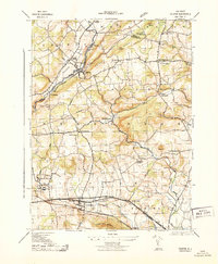
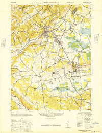
 1947 Mendham1947 Print · USGSMorris County's landscape in the late 1940s balances growing settlements with massive institutions and protected parklands. Genealogists can locate family sites near Mendham or trace the grounds of the Greystone Park State Hospital for Insane.
 - 1947 Map of Dover
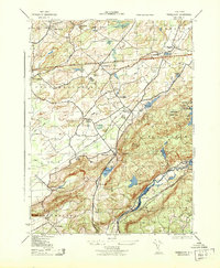
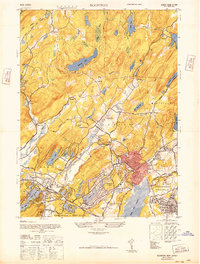
 1947 Dover1947 Print · USGSDover and the Rockaway River valley are captured in the late 1940s, showing a landscape defined by industrial centers and lakeside retreats. Trace local history along the Morris Canal or find landmarks like the Star of the Sea Church and Wharton.
 - 1947 Map of Caldwell
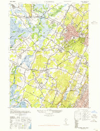 1947 Caldwell1947 Print · USGSEssex and Morris Counties are shown just after the war, when a network of small airports and golf courses integrated with established boroughs. Researchers can trace the legacy of Hatfield Swamp or locate family sites near Restland Cemetery and Morehousetown.
 - 1947 Map of Chatham
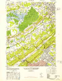 1947 Chatham1947 Print · USGSThe Morris and Union County borderlands appear here in the late 1940s as a mix of preserved marshland and rapid suburban growth. Researchers can trace the rail-side development of Stirling and Gillette or locate historic sites like the Bonnie Burn Sanatorium and Murray Hill Sta.2 unique versions available
 - 1947 Map of Boonton
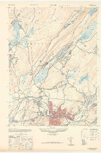
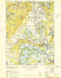
 1947 Boonton1947 Print · USGSPost-war Morris County is captured here as a landscape of massive reservoirs, iron mining roots, and growing suburban lake communities. Genealogists and historians can trace the industrial footprint of the Hibernia Mine or locate early aviation sites like the Aircraft Radio Corporation Airport.
 - 1947 Map of Morristown
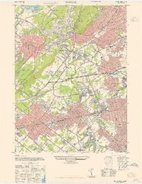
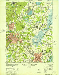 1947 Morristown1947 Print · USGSMorris County was undergoing rapid post-war growth when this survey recorded its transitioning rail-and-river landscape. Genealogists and local historians can trace the foundations of Morristown, Madison, and Whippany, alongside major landmarks like Greystone Park State Hospital and Washingtons Hdqtrs.
 - 1947 Map of Roselle
 1947 Roselle1947 Print · USGSThe northern Union County suburbs were rapidly expanding in the late 1940s as rail networks and park systems matured. Genealogists and local historians can trace the development of Summit, Kenilworth, and Linden alongside landmarks like Cranford Junction and Fairview Cem.2 unique versions available
 - 1947 Map of Bernardsville
 1947 Bernardsville1947 Print · USGSSomerset County saw significant development following the war as the rail network linked historic villages with new institutional centers. Genealogists can locate family landmarks like Osborn Mills, the Stone House, and the Greenlawn Memory Park Cem.
 - 1947 Map of Pompton Plains
 1947 Pompton Plains1947 Print · USGSNorth Jersey was a hub of early aviation and rail travel in the late 1940s, where small airfields and major rail lines intersected. You can trace historic routes through Pompton Plains, locate North Jersey Airport, and follow the Erie RR through the valley.2 unique versions available
 - 1948 Map of Wanaque
 1948 Wanaque1948 Print · USGSNorthern New Jersey's Highlands were entering a period of significant post-war growth when this survey recorded the communities around the Wanaque Reservoir. Genealogists and local historians can trace family roots in Haskell, Bloomingdale, and Midvale, or locate landmarks like the Aquehonga Sch.2 unique versions available
 - 1949 Map of Newark
 1949 Newark1949 Print · USGSThe industrial corridor between Philadelphia and New York comes alive in this post-war survey. Genealogists and historians can trace the massive rail networks of the Reading Railroad and locate major installations like Fort Dix or Picatinny Arsenal.2 unique versions available
End of results
Showing maps 1-24 of 24
Top cities of Morris County
- Parsippany-Troy Hills historical maps
- Mount Olive historical maps
- Rockaway Township historical maps
- Roxbury Township historical maps
- Montville Township historical maps
- Morristown historical maps
See more
Frequently asked questions
- What are the different types of historical maps available for Morris County?
- What is the oldest map of Morris County?
- Where can I purchase historical maps of Morris County for my home or office?
- Where can I download high-res historical maps of Morris County?
- Are there historical topographic maps available for Morris County?
- Is there historical aerial imagery available for Morris County?
- Where are historical maps of Morris County sourced from?