1940s Maps of Rockaway Township, New Jersey
Explore 7 historic maps of Rockaway Township from the 1940s. These maps offer a rare glimpse into what life looked like during the 1940s — showing old roads, neighborhoods, homes, and landmarks that have changed or disappeared over time.
Whether you're researching your family's past, planning a metal detecting trip, or studying how Rockaway Township's landscape evolved across the 1940s, these high-resolution maps are a powerful tool for exploring the history of this region.
- Focus on a specific era: All maps on this page are from the 1940s, giving you a focused view of this time period.
- See what’s changed: Compare century-old streets, trails, and buildings to today's modern landscape using overlays and satellite layers.
- Research with precision: Use these maps for genealogy, historical research, land use analysis, or educational projects.
- View, download, or print: Maps are fully viewable online in high resolution, and can be downloaded or printed for your own records.
Start exploring Rockaway Township's history through authentic maps from the 1940s. This is your window into the past.
Rockaway Township, NJ maps
(7)- 1942 Map of Passaic
 1942 Passaic1942 Print · USGSNorthern New Jersey and New York harbor appear in detail at the start of the war, showing a landscape of burgeoning suburbs and vital industry. Trace family roots and local history across the Passaic River valley, from Paterson to the Watchung Mountains.
 - 1943 Map of Franklin Furnace
 1943 Franklin Furnace1943 Print · USGSMid-century Sussex County is defined here by its deep mining roots and mountain reservoirs. Trace the industrial landscape of Franklin and Ogdensburg through landmarks like the N J Zinc Co, the Stockholm School, and the Lehigh and Hudson River.
 - 1943 Map of Newfoundland
 1943 Newfoundland1943 Print · USGSThe Pequannock River valley and its surrounding ridges are captured here during the Second World War. Researchers can trace the New York Susquehanna and Western rail line through Newfoundland or locate landmarks like the Fire House and West Milford School.
 - 1944 Map of Newark, 1971 Print
 1944 Newark1971 Print · USGSThe industrial corridor from Philadelphia to New York was in a period of massive transition during the mid-forties. Genealogists and researchers can trace the rail lines of the Lehigh Valley RR, locate military installations like Picatinny Arsenal, and explore the early sprawl near Levittown.5 unique versions available
 - 1947 Map of Dover
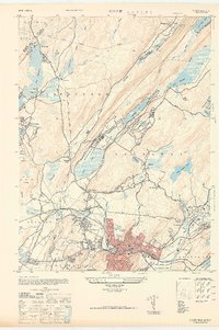 1947 Dover1947 Print · USGSDover and the Rockaway River valley are captured in the late 1940s, showing a landscape defined by industrial centers and lakeside retreats. Trace local history along the Morris Canal or find landmarks like the Star of the Sea Church and Wharton.
 - 1947 Map of Boonton
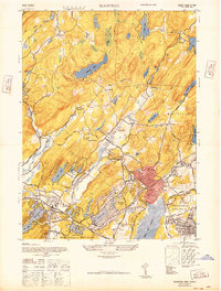 1947 Boonton1947 Print · USGSPost-war Morris County is captured here as a landscape of massive reservoirs, iron mining roots, and growing suburban lake communities. Genealogists and historians can trace the industrial footprint of the Hibernia Mine or locate early aviation sites like the Aircraft Radio Corporation Airport.
 - 1949 Map of Newark
 1949 Newark1949 Print · USGSThe industrial corridor between Philadelphia and New York comes alive in this post-war survey. Genealogists and historians can trace the massive rail networks of the Reading Railroad and locate major installations like Fort Dix or Picatinny Arsenal.2 unique versions available
End of results
Showing maps 1-7 of 7
Top cities near Rockaway Township
- Wayne historical maps
- Parsippany-Troy Hills historical maps
- West Orange historical maps
- Warwick historical maps
- Mount Olive historical maps
- Livingston historical maps
See more
Top neighborhoods of Rockaway Township
- Lyonsville historical maps
- Marcella historical maps
- Meriden historical maps
- Hilltown historical maps
- Beach Glen historical maps
- Kitchell historical maps
See more
Frequently asked questions
- What are the different types of historical maps available for Rockaway Township?
- What is the oldest map of Rockaway Township?
- Where can I purchase historical maps of Rockaway Township for my home or office?
- Where can I download high-res historical maps of Rockaway Township?
- Are there historical topographic maps available for Rockaway Township?
- Is there historical aerial imagery available for Rockaway Township?
- Where are historical maps of Rockaway Township sourced from?