1950s Maps of Lakewood Township, New Jersey
Explore 4 historic maps of Lakewood Township from the 1950s. These maps offer a rare glimpse into what life looked like during the 1950s — showing old roads, neighborhoods, homes, and landmarks that have changed or disappeared over time.
Whether you're researching your family's past, planning a metal detecting trip, or studying how Lakewood Township's landscape evolved across the 1950s, these high-resolution maps are a powerful tool for exploring the history of this region.
- Focus on a specific era: All maps on this page are from the 1950s, giving you a focused view of this time period.
- See what’s changed: Compare century-old streets, trails, and buildings to today's modern landscape using overlays and satellite layers.
- Research with precision: Use these maps for genealogy, historical research, land use analysis, or educational projects.
- View, download, or print: Maps are fully viewable online in high resolution, and can be downloaded or printed for your own records.
Start exploring Lakewood Township's history through authentic maps from the 1950s. This is your window into the past.
Lakewood Township, NJ maps
(4)- 1954 Map of Lakewood, 1956 Print
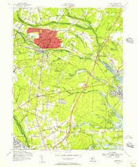 1954 Lakewood1956 Print · USGSMid-century Ocean County is captured during a period of growth, centered on the historic resort community of Lakewood and its surrounding townships. Researchers can trace family sites and local institutions through landmarks like Georgian Court College, Seven Stars, and the Mt Sinai Cem.3 unique versions available
 - 1956 Map of Newark
 1956 Newark1956 Print · USGSThe industrial heart of the Mid-Atlantic is captured here at the dawn of the highway era, tracing the dense corridors between Newark and Philadelphia. Genealogists and local historians can map the rail networks of the Reading RR or locate mid-century military life at Fort Dix Military Reservation.2 unique versions available
 - 1957 Map of Newark
 1957 Newark1957 Print · USGSThe industrial and military heart of the Mid-Atlantic is mapped during its post-war suburban boom. Genealogists and historians can trace the intricate rail corridors of the Reading Railroad and locate key landmarks from Princeton University to Fort Hancock.
 - 1957 Map of Lakehurst, 1961 Print
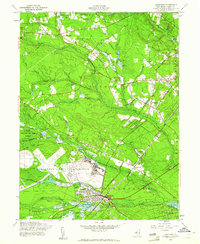 1957 Lakehurst1961 Print · USGSMid-century Ocean County is captured here during a period of military prominence and agricultural tradition. Researchers can trace the sprawling Lakehurst Naval Air Station, the rail lines of the C RR of N J, and numerous Cranberry Bogs.3 unique versions available
End of results
Showing maps 1-4 of 4
Top cities near Lakewood Township
- Toms River historical maps
- Brick Township historical maps
- Howell Township historical maps
- Jackson Township historical maps
- Monroe Township historical maps
- Manchester Township historical maps
See more
Top neighborhoods of Lakewood Township
- A Country Place historical maps
- Coventry Square historical maps
- South Lakewood historical maps
- Greenville historical maps
- Leisure Village historical maps
- Leisure Village East historical maps
See more
Frequently asked questions
- What are the different types of historical maps available for Lakewood Township?
- What is the oldest map of Lakewood Township?
- Where can I purchase historical maps of Lakewood Township for my home or office?
- Where can I download high-res historical maps of Lakewood Township?
- Are there historical topographic maps available for Lakewood Township?
- Is there historical aerial imagery available for Lakewood Township?
- Where are historical maps of Lakewood Township sourced from?