1990s Maps of West Milford, New Jersey
Explore 3 historic maps of West Milford from the 1990s. These maps offer a rare glimpse into what life looked like during the 1990s — showing old roads, neighborhoods, homes, and landmarks that have changed or disappeared over time.
Whether you're researching your family's past, planning a metal detecting trip, or studying how West Milford's landscape evolved across the 1990s, these high-resolution maps are a powerful tool for exploring the history of this region.
- Focus on a specific era: All maps on this page are from the 1990s, giving you a focused view of this time period.
- See what’s changed: Compare century-old streets, trails, and buildings to today's modern landscape using overlays and satellite layers.
- Research with precision: Use these maps for genealogy, historical research, land use analysis, or educational projects.
- View, download, or print: Maps are fully viewable online in high resolution, and can be downloaded or printed for your own records.
Start exploring West Milford's history through authentic maps from the 1990s. This is your window into the past.
West Milford, NJ maps
(3)- 1994 Map of Wawayanda, 1998 Print
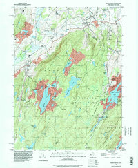 1994 Wawayanda1998 Print · USGSThe Highlands of northern New Jersey meet the New York border in the 1990s, where protected forests and ridge-top trails define the landscape. Trace the Appalachian Trail past Highland Lakes or locate family roots near Glenwood Cem and Greenwood Ch.
 - 1995 Map of Wanaque, 2000 Print
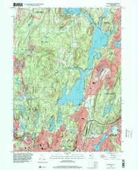 1995 Wanaque2000 Print · USGSMid-1990s Passaic County is defined by the massive Wanaque Reservoir and its surrounding state forests. Researchers can trace local landmarks like the Eleanor Hewitt Sch, the Midvale Dam, and the early industrial heritage of Longpond Ironworks State Park.
 - 1997 Map of Newfoundland, 1998 Print
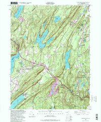 1997 Newfoundland1998 Print · USGSNorthern New Jersey's Highlands were a critical water and transit corridor in the late twentieth century. You can trace the NEW YORK SUSQUEHANNA AND WESTERN railroad past Newfoundland and locate the Vreeland Cem and Turner Cem.
End of results
Showing maps 1-3 of 3
Top cities near West Milford
- New York historical maps
- Ramapo historical maps
- Paterson historical maps
- Clifton historical maps
- Wayne historical maps
- Parsippany-Troy Hills historical maps
See more
Top neighborhoods of West Milford
- Upper Greenwood Lake historical maps
- Uttertown historical maps
- Charlotteburg historical maps
- Clinton historical maps
- Oak Ridge historical maps
- Postville historical maps
See more
Frequently asked questions
- What are the different types of historical maps available for West Milford?
- What is the oldest map of West Milford?
- Where can I purchase historical maps of West Milford for my home or office?
- Where can I download high-res historical maps of West Milford?
- Are there historical topographic maps available for West Milford?
- Is there historical aerial imagery available for West Milford?
- Where are historical maps of West Milford sourced from?