1990s Maps of Lower Alloways Creek Township, New Jersey
Explore 6 historic maps of Lower Alloways Creek Township from the 1990s. These maps offer a rare glimpse into what life looked like during the 1990s — showing old roads, neighborhoods, homes, and landmarks that have changed or disappeared over time.
Whether you're researching your family's past, planning a metal detecting trip, or studying how Lower Alloways Creek Township's landscape evolved across the 1990s, these high-resolution maps are a powerful tool for exploring the history of this region.
- Focus on a specific era: All maps on this page are from the 1990s, giving you a focused view of this time period.
- See what’s changed: Compare century-old streets, trails, and buildings to today's modern landscape using overlays and satellite layers.
- Research with precision: Use these maps for genealogy, historical research, land use analysis, or educational projects.
- View, download, or print: Maps are fully viewable online in high resolution, and can be downloaded or printed for your own records.
Start exploring Lower Alloways Creek Township's history through authentic maps from the 1990s. This is your window into the past.
Lower Alloways Creek Township, NJ maps
(6)- 1993 Map of Canton
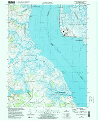
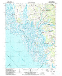 1993 Canton1993 Print · USGSCoastal Salem County comes into focus in the early nineties, showing a landscape defined by the vast marshlands of the Delaware Bay. Researchers can trace historic crossroads and tide-water landmarks from Harmersville down to Stow Creek Landing and the old milling site at Maskells Mill.
 - 1993 Map of Taylors Bridge
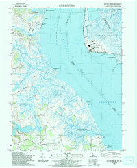 1993 Taylors Bridge1993 Print · USGSThe Delaware shoreline and tidal marshes are captured in the early 1990s as the Salem Nuclear Powerplant stands opposite historic rural landings. Researchers can trace local genealogy and land use through Taylors Bridge, old schools along Walker School Road, and the family-named Thomas Landing.
 - 1993 Map of Delaware City
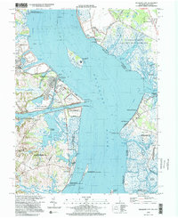
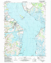 1993 Delaware City1993 Print · USGSThe Delaware riverfront and its coastal defenses appear in detail during the early nineties, showing the historic corridor between Delaware and New Jersey. Genealogists and historians can trace riverside settlements like Port Penn, the site of Fort Elfsborg, and the Finns Point National Cemetery.
 - 1995 Map of Salem, 1999 Print
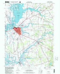 1995 Salem1999 Print · USGSThe riverfront and marshlands of Salem County are detailed in the mid-1990s, capturing a landscape of tidal meadows and historic villages. Local historians can locate landmarks like Majors Wharf, Evergreen Cem, and the Wyncoop Sch.
 - 1999 Map of Taylors Bridge, 2001 Print
 1999 Taylors Bridge2001 Print · USGSThe Delaware riverfront at the close of the century shows a unique mix of heavy industry and coastal preservation. Genealogists and researchers can trace family-named sites like Taylors Bridge, Thomas Landing, and Fennimore Landing alongside the Salem Nuclear Powerplant.
 - 1999 Map of Delaware City, 2001 Print
 1999 Delaware City2001 Print · USGSThe Delaware River shoreline at the close of the twentieth century reveals a landscape defined by historic river forts and sprawling coastal wetlands. Researchers can trace the heritage of Delaware City and Port Penn or locate the Finns Point National Cemetery.
End of results
Showing maps 1-6 of 6
Top cities near Lower Alloways Creek Township
- Wilmington historical maps
- Bridgeton historical maps
- Pennsville Township historical maps
- Smyrna historical maps
- Middletown historical maps
- Wilmington Manor historical maps
See more
Top neighborhoods of Lower Alloways Creek Township
- Maskells Mill historical maps
- Hancocks Bridge historical maps
- Canton historical maps
- Hagerville historical maps
- Harmersville historical maps
Frequently asked questions
- What are the different types of historical maps available for Lower Alloways Creek Township?
- What is the oldest map of Lower Alloways Creek Township?
- Where can I purchase historical maps of Lower Alloways Creek Township for my home or office?
- Where can I download high-res historical maps of Lower Alloways Creek Township?
- Are there historical topographic maps available for Lower Alloways Creek Township?
- Is there historical aerial imagery available for Lower Alloways Creek Township?
- Where are historical maps of Lower Alloways Creek Township sourced from?