1990s Maps of Quinton Township, New Jersey
Explore 2 historic maps of Quinton Township from the 1990s. These maps offer a rare glimpse into what life looked like during the 1990s — showing old roads, neighborhoods, homes, and landmarks that have changed or disappeared over time.
Whether you're researching your family's past, planning a metal detecting trip, or studying how Quinton Township's landscape evolved across the 1990s, these high-resolution maps are a powerful tool for exploring the history of this region.
- Focus on a specific era: All maps on this page are from the 1990s, giving you a focused view of this time period.
- See what’s changed: Compare century-old streets, trails, and buildings to today's modern landscape using overlays and satellite layers.
- Research with precision: Use these maps for genealogy, historical research, land use analysis, or educational projects.
- View, download, or print: Maps are fully viewable online in high resolution, and can be downloaded or printed for your own records.
Start exploring Quinton Township's history through authentic maps from the 1990s. This is your window into the past.
Quinton Township, NJ maps
(2)- 1993 Map of Canton
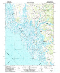 1993 Canton1993 Print · USGSCoastal Salem County comes into focus in the early nineties, showing a landscape defined by the vast marshlands of the Delaware Bay. Researchers can trace historic crossroads and tide-water landmarks from Harmersville down to Stow Creek Landing and the old milling site at Maskells Mill.
 - 1995 Map of Salem, 1999 Print
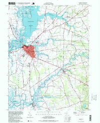 1995 Salem1999 Print · USGSThe riverfront and marshlands of Salem County are detailed in the mid-1990s, capturing a landscape of tidal meadows and historic villages. Local historians can locate landmarks like Majors Wharf, Evergreen Cem, and the Wyncoop Sch.
End of results
Showing maps 1-2 of 2
Top cities near Quinton Township
- Wilmington historical maps
- Bridgeton historical maps
- Glassboro historical maps
- Mantua Township historical maps
- Pennsville Township historical maps
- Smyrna historical maps
See more
Top neighborhoods of Quinton Township
- Harmony historical maps
- Woodmere historical maps
- Pecks Corner historical maps
- Mickles Mill historical maps
- Elks Terrace historical maps
- Schepps Valley historical maps
See more
Frequently asked questions
- What are the different types of historical maps available for Quinton Township?
- What is the oldest map of Quinton Township?
- Where can I purchase historical maps of Quinton Township for my home or office?
- Where can I download high-res historical maps of Quinton Township?
- Are there historical topographic maps available for Quinton Township?
- Is there historical aerial imagery available for Quinton Township?
- Where are historical maps of Quinton Township sourced from?