1900s (20th Century) Maps of LH Ranch, New Mexico
Explore 9 historic maps of LH Ranch from the 1900s (20th Century). These maps offer a rare glimpse into what life looked like during the 1900s — showing old roads, neighborhoods, homes, and landmarks that have changed or disappeared over time.
Whether you're researching your family's past, planning a metal detecting trip, or studying how LH Ranch's landscape evolved across the 1900s, these high-resolution maps are a powerful tool for exploring the history of this region.
- Focus on a specific era: All maps on this page are from the 1900s, giving you a focused view of this time period.
- See what’s changed: Compare century-old streets, trails, and buildings to today's modern landscape using overlays and satellite layers.
- Research with precision: Use these maps for genealogy, historical research, land use analysis, or educational projects.
- View, download, or print: Maps are fully viewable online in high resolution, and can be downloaded or printed for your own records.
Start exploring LH Ranch's history through authentic maps from the 1900s. This is your window into the past.
LH Ranch, NM maps
(9)- 1910 Map of Mogollon, 1959 Print
 1910 Mogollon1959 Print · USGSThe high mining camps and river settlements of Catron County come alive in this survey from the early 1900s. Genealogists and historians can trace old homesteads and industrial sites like the Meader Stage Sta, Box N Ranch, and the Power Plant near Graham.2 unique versions available
 - 1912 Map of Mogollon
 1912 Mogollon1912 Print · USGSNew Mexico's high timber and mining country come to life in this survey from the years just before statehood. Researchers can trace the early industrial footprint of Cooney and Mogollon or locate remote outposts like Meadows Stage Sta and N Bar Ranch.2 unique versions available
 - 1954 Map of Clifton, 1968 Print
 1954 Clifton1968 Print · USGSThe high timber and copper country of the Arizona-New Mexico border is captured here during the mid-fifties. Genealogists and historians can trace family holdings like the Double Circle Ranch or study the industrial footprint of the Smelting Plant at Clifton.3 unique versions available
 - 1957 Map of Clifton
 1957 Clifton1957 Print · USGSThe copper-mining district around Clifton and Morenci meets the high timberlands of the Mogollon Rim during the mid-1950s. Genealogists and researchers can trace family-named outposts and remote mountain settlements like Reserve, Stargo, and Fort Thomas.
 - 1958 Map of Clifton
 1958 Clifton1958 Print · USGSThe rugged high country of the Arizona-New Mexico border comes into focus in the mid-fifties, showing a landscape of mining camps and forest outposts. Genealogists and researchers can trace old settlements and remote sites like Mogollon, East Fork Mission, and the Tidwell Mine.
 - 1962 Map of Clifton
 1962 Clifton1962 Print · USGSThe copper-rich Arizona-New Mexico borderlands come into focus in the early sixties, centered on the mining complexes of Morenci and Clifton. Researchers can trace the Southern Pacific rail lines and locate remote outposts like Honeymoon and the Double Circle Ranch.
 - 1963 Map of Alma, 1966 Print
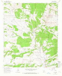 1963 Alma1966 Print · USGSAlma and the surrounding ranchlands of Catron County appear here in the early 1960s, showing the intersection of forest service lands and private holdings. Local researchers can trace family landmarks like the L H Ranch and B McKeen Ranch or locate the Cem near the San Francisco River.2 unique versions available
 - 1985 Map of Mogollon Mountains
 1985 Mogollon Mountains1985 Print · USGSThe high wilderness of Catron and Grant counties is shown in the mid-1980s, documenting the remote canyons and peaks of the Gila region. Researchers can trace the proximity of historic mining sites like Confidence Mine to small mountain towns such as Mogollon and Glenwood.
 - 1999 Map of Alma, 2002 Print
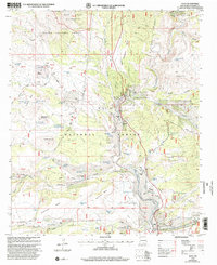 1999 Alma2002 Print · USGSWestern Catron County ranching culture thrives along the San Francisco River and its rugged canyons at the turn of the millennium. Genealogists and historians can trace family properties like the W Spurgeon Ranch, locate the Cem at Alma, and find local landmarks such as the Historical Bridge.
End of results
Showing maps 1-9 of 9
Frequently asked questions
- What are the different types of historical maps available for LH Ranch?
- What is the oldest map of LH Ranch?
- Where can I purchase historical maps of LH Ranch for my home or office?
- Where can I download high-res historical maps of LH Ranch?
- Are there historical topographic maps available for LH Ranch?
- Is there historical aerial imagery available for LH Ranch?
- Where are historical maps of LH Ranch sourced from?