1950s Maps of Piedra Lumbre, New Mexico
Explore 2 historic maps of Piedra Lumbre from the 1950s. These maps offer a rare glimpse into what life looked like during the 1950s — showing old roads, neighborhoods, homes, and landmarks that have changed or disappeared over time.
Whether you're researching your family's past, planning a metal detecting trip, or studying how Piedra Lumbre's landscape evolved across the 1950s, these high-resolution maps are a powerful tool for exploring the history of this region.
- Focus on a specific era: All maps on this page are from the 1950s, giving you a focused view of this time period.
- See what’s changed: Compare century-old streets, trails, and buildings to today's modern landscape using overlays and satellite layers.
- Research with precision: Use these maps for genealogy, historical research, land use analysis, or educational projects.
- View, download, or print: Maps are fully viewable online in high resolution, and can be downloaded or printed for your own records.
Start exploring Piedra Lumbre's history through authentic maps from the 1950s. This is your window into the past.
Piedra Lumbre, NM maps
(2)- 1957 Map of Arch Mesa, 1959 Print
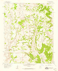 1957 Arch Mesa1959 Print · USGSThe intersection of the Canoncito Navajo Indian Reservation and Laguna Indian Reservation is recorded here in the late 1950s. You can trace isolated Ruins, remote livestock water sources like Meyer Windmill, and prominent landmarks such as Standing Rock.3 unique versions available
 - 1958 Map of Albuquerque
 1958 Albuquerque1958 Print · USGSAlbuquerque and the surrounding high desert are captured here during a period of massive federal expansion and postwar growth. Researchers can trace the development of Kirtland Air Force Base, find ancestral homes in Pueblo de Santa Ana, or locate industrial sites like the Jackpile Mine.
End of results
Showing maps 1-2 of 2
Top cities near Piedra Lumbre
Frequently asked questions
- What are the different types of historical maps available for Piedra Lumbre?
- What is the oldest map of Piedra Lumbre?
- Where can I purchase historical maps of Piedra Lumbre for my home or office?
- Where can I download high-res historical maps of Piedra Lumbre?
- Are there historical topographic maps available for Piedra Lumbre?
- Is there historical aerial imagery available for Piedra Lumbre?
- Where are historical maps of Piedra Lumbre sourced from?