Old Maps of Corralitos Ranch, New Mexico
Explore 11 old maps of Corralitos Ranch, spanning from 1943 to today. These high-resolution historic maps reveal how streets, neighborhoods, landmarks, and natural features evolved over time — perfect for genealogy, metal detecting, research, and local history exploration.
What you can do with these maps:
- See how Corralitos Ranch changed over time: Compare historical maps to modern-day views to trace roads, homesites, rail lines & more.
- View detailed metadata: Each map includes creators, publishers, year, scale, and archive source.
- Overlay maps with satellite & LiDAR: Visualize the past alongside modern tools to explore terrain & human change.
- Trusted historical sources: Maps sourced from the USGS, Library of Congress, and other archives.
- Access maps your way: View online, download high-res files, or order prints for personal or research use.
Start exploring old maps of Corralitos Ranch to uncover forgotten places, hidden landmarks, and the deep history beneath your feet.
Corralitos Ranch, NM maps
(11)- 1943 Map of Corralitos Ranch
 1943 Corralitos Ranch1943 Print · USGSMid-century Doña Ana County ranching life is preserved here, showing an arid landscape managed through a complex system of remote outposts and wells. Researchers can trace the legacy of the Corralitos Ranch, locate the RUINS OF FORT MASON, and find the Old LeFebre Ranch.2 unique versions available
 - 1955 Map of Las Cruces, 1963 Print
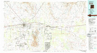
 1955 Las Cruces1963 Print · USGSSouthern New Mexico comes into focus during the mid-fifties, showing the growth of Las Cruces alongside major military and scientific installations. Genealogists and historians can trace the Southern Pacific tracks through small rail towns like Cambray and Afton, or locate family sites near Hatch and Deming.3 unique versions available
 - 1958 Map of Las Cruces
 1958 Las Cruces1958 Print · USGSSouthern New Mexico in the late fifties was a landscape of rapid scientific and military growth centered on the Rio Grande. Local historians can trace the development of Las Cruces, the campus of New Mexico A and M College, and remote rail sidings like Aden Siding.
 - 1982 Map of Deming, 1983 Print
 1982 Deming1983 Print · USGSDeming and the surrounding high desert emerge in the early 1980s as a vital transportation and mining corridor. Genealogists and historians can trace the rail sidings of Cambray and Akela or locate the historic Fort Cummings (Ruins) near the Cookes Range.2 unique versions available
 - 1985 Map of Sleeping Lady Hills
 1985 Sleeping Lady Hills1985 Print · USGSDona Ana County’s high desert is captured here in the mid-eighties, featuring the prominent peaks of the Sleeping Lady Hills. Researchers can trace the legacy of regional transport along the Atchison Topeka and Santa Fe Ry and an old Historic Trail.
 - 1996 Map of Sleeping Lady Hills, 2001 Print
 1996 Sleeping Lady Hills2001 Print · USGSThe high desert of Doña Ana County in the mid-1990s is captured here, showing a landscape shaped by ranching and old western routes. Researchers can trace the path of a Historic Trail or locate remote landmarks like Reichey Butte and Rough and Ready Gap.
 - 2010 Map of Sleeping Lady Hills, 2010 Print
 2010 Sleeping Lady Hills2010 Print · USGSCovers Corralitos Ranch, including Doña Ana County, United States, and other nearby areas
 - 2013 Map of Sleeping Lady Hills, 2013 Print
 2013 Sleeping Lady Hills2013 Print · USGSCovers Corralitos Ranch, including Doña Ana County, United States, and other nearby areas
 - 2017 Map of Sleeping Lady Hills, 2017 Print
 2017 Sleeping Lady Hills2017 Print · USGSCovers Corralitos Ranch, including Doña Ana County, United States, and other nearby areas
 - 2020 Map of Sleeping Lady Hills, 2020 Print
 2020 Sleeping Lady Hills2020 Print · USGSCovers Corralitos Ranch, including Doña Ana County, United States, and other nearby areas
 - 2023 Map of Sleeping Lady Hills, 2023 Print
 2023 Sleeping Lady Hills2023 Print · USGSDoña Ana County's high desert is captured here in the early 2020s, showing a landscape shaped by volcanic terrain and water management. Researchers can trace land use through stock tanks like Martin Tank and navigate the gaps in the Sleeping Lady Hills.
End of results
Showing maps 1-11 of 11
Top cities near Corralitos Ranch
Frequently asked questions
- What are the different types of historical maps available for Corralitos Ranch?
- What is the oldest map of Corralitos Ranch?
- Where can I purchase historical maps of Corralitos Ranch for my home or office?
- Where can I download high-res historical maps of Corralitos Ranch?
- Are there historical topographic maps available for Corralitos Ranch?
- Is there historical aerial imagery available for Corralitos Ranch?
- Where are historical maps of Corralitos Ranch sourced from?