
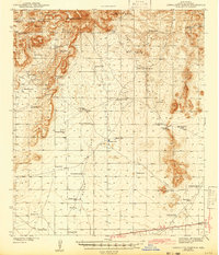
1943 Map of Corralitos Ranch
USGS Topo · Published 1943About this map
Ruins of Fort Mason sits near the center of this high-desert landscape, offering a window into the frontier military history of Doña Ana County during the early 1940s. The map reveals an intricate network of water management essential for ranching, dominated by the Corralitos Ranch and the Old LeFebre Ranch. Every few miles, the terrain is dotted with life-sustaining features like Mimms Well, Temple Well, and Coyote Tank, showing how the cattle industry adapted to the arid environment.
Find a feature on this map
56 named features on this map. Tap any name to fly to it.
Don’t see what you’re looking for? This feature index may not catch every label — zoom into the map to look around manually.
Map Details
Editions of this 1943 Corralitos Ranch Map
2 editions found
Other maps of this area

1891 · Las Cruces
USGS Topo · 1:125,000

1893 · Las Cruces
USGS Topo · 1:125,000

1916 · Tonuco
USGS Topo · 1:125,000

1932 · Tonuco
USGS Topo · 1:125,000

1941 · Las Cruces
USGS Topo · 1:62,500

1941 · Aden
USGS Topo · 1:62,500

1943 · Aden
USGS Topo · 1:62,500

1943 · Afton
USGS Topo · 1:62,500

1943 · Las Cruces
USGS Topo · 1:62,500

1948 · San Diego Mountain
USGS Topo · 1:62,500