Old Maps of Las Cruces, New Mexico
Explore 51 old maps of Las Cruces, spanning from 1891 to today. These high-resolution historic maps reveal how streets, neighborhoods, landmarks, and natural features evolved over time — perfect for genealogy, metal detecting, research, and local history exploration.
What you can do with these maps:
- See how Las Cruces changed over time: Compare historical maps to modern-day views to trace roads, homesites, rail lines & more.
- View detailed metadata: Each map includes creators, publishers, year, scale, and archive source.
- Overlay maps with satellite & LiDAR: Visualize the past alongside modern tools to explore terrain & human change.
- Trusted historical sources: Maps sourced from the USGS, Library of Congress, and other archives.
- Access maps your way: View online, download high-res files, or order prints for personal or research use.
Start exploring old maps of Las Cruces to uncover forgotten places, hidden landmarks, and the deep history beneath your feet.
Las Cruces, NM maps
(51)- 1891 Map of Las Cruces
 1891 Las Cruces1891 Print · USGSThe Mesilla Valley and Organ Mountains are shown here during the late territorial era, when the railroad was transforming the region. Genealogists and historians can trace early settlements like Mesilla, Fort Selden, and the mining hub at Organ City.
 - 1893 Map of Las Cruces
 1893 Las Cruces1893 Print · USGSSettlements along the Rio Grande flourished in the 1890s as the railroad arrived in Doña Ana County. Genealogists can trace family roots in Mesilla, Las Cruces, and Santa Tomaz, or locate the historic site of Fort Selden.4 unique versions available
 - 1941 Map of Las Cruces, 1958 Print
 1941 Las Cruces1958 Print · USGSThe Rio Grande valley comes alive in the early 1940s, showing a landscape defined by irrigation and early college life. Trace family roots at Mesilla, the Ruins of Fort Selden, or the grounds of New Mexico State College.2 unique versions available
 - 1941 Map of Organ Peak, 1961 Print
 1941 Organ Peak1961 Print · USGSDona Ana County was a land of high desert peaks and isolated ranching outposts in the early 1940s. Genealogists and historians can locate family-named landmarks like the Will F. Isaacs Ranch and Beasley Ranch, or trace the grounds of New Mexico State College.2 unique versions available
 - 1943 Map of Organ Peak
 1943 Organ Peak1943 Print · USGSDona Ana County is captured here in the early 1940s, showing the intersection of high desert ranching and the growth of the state college. Genealogists and historians can locate family holdings like Beasley Ranch, the settlement of Organ, and the Modoc Mine.2 unique versions available
 - 1943 Map of Afton
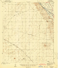 1943 Afton1943 Print · USGSThe Mesilla Valley during the early 1940s is shown here as a landscape of intensive river irrigation and isolated desert ranching. Genealogists can locate family holdings such as Norwood Ranch and Nunn Ranch or trace the early community boundaries of the Mesilla Civil Colony.3 unique versions available
 - 1943 Map of Las Cruces
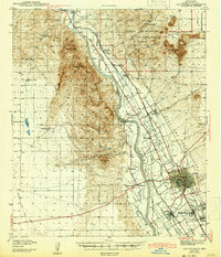 1943 Las Cruces1943 Print · USGSThe Mesilla Valley in the early 1940s reveals a complex network of irrigation canals and historic river settlements. Genealogists and researchers can trace the early footprints of New Mexico State College, the Ruins of Fort Selden, and local institutions like Loretto Academy.
 - 1955 Map of Tortugas Mountain, 1962 Print
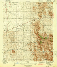
 1955 Tortugas Mountain1962 Print · USGSDona Ana County in the mid-fifties showcases a landscape of growing academic institutions and historic land colonies. Genealogists and historians can trace the foundations of New Mexico State College, the Fort Fillmore (Ruins), and the Tortugas Cem.2 unique versions available
 - 1955 Map of Organ Peak NW, 1962 Print
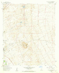
 1955 Organ Peak NW1962 Print · USGSSouthern New Mexico’s high desert is captured here in the mid-fifties, showing the intersection of scientific research and military land use. Researchers can trace essential water infrastructure across the Jornada basin through features like Isaack Lake, Petts Tank, and Washington Tank.2 unique versions available
 - 1955 Map of Las Cruces, 1963 Print
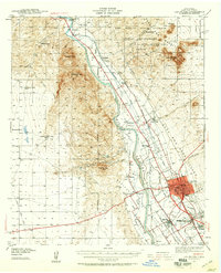
 1955 Las Cruces1963 Print · USGSSouthern New Mexico comes into focus during the mid-fifties, showing the growth of Las Cruces alongside major military and scientific installations. Genealogists and historians can trace the Southern Pacific tracks through small rail towns like Cambray and Afton, or locate family sites near Hatch and Deming.3 unique versions available
 - 1958 Map of Las Cruces
 1958 Las Cruces1958 Print · USGSSouthern New Mexico in the late fifties was a landscape of rapid scientific and military growth centered on the Rio Grande. Local historians can trace the development of Las Cruces, the campus of New Mexico A and M College, and remote rail sidings like Aden Siding.
 - 1978 Map of Las Cruces
 1978 Las Cruces1978 Print · USGSLas Cruces and the Rio Grande valley are shown in detail during the late seventies, a period of steady growth along the railroad. Local historians can trace the irrigation networks of the Leasburg Canal and locate neighborhood landmarks like Mesilla Park and Tortugas.
 - 1978 Map of Dona Ana, 1994 Print
 1978 Dona Ana1994 Print · USGSThe Mesilla Valley in the late seventies reveals a landscape of high-desert peaks and complex Rio Grande irrigation. Trace the development of Doña Ana and the Animal Science Ranch or locate the Cem and Doña Ana-East Picacho Sch near the river.
 - 1978 Map of Picacho Mountain, 1994 Print
 1978 Picacho Mountain1994 Print · USGSThe West Mesa of the Mesilla Valley comes into focus in the late 1970s, showcasing a mix of desert aviation and colonial land grants. You can trace the development of the State Fairground, the Las Cruces International Airport, and historic land divisions like the Mesilla Civil Colony Tract No 2.
 - 1982 Map of Las Cruces
 1982 Las Cruces1982 Print · USGSThe Rio Grande valley and the Organ Mountains define this 1980s portrait of southern New Mexico's ranching and military landscape. Trace historic land divisions like the Brazito Grant alongside landmarks such as Santo Tomas and the Silver King Mine.
 - 1996 Map of Afton NW, 2001 Print
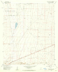
 1996 Afton NW2001 Print · USGSThe high desert of southern New Mexico appears in the late nineties as a landscape defined by survey geometry and industrial utility. Genealogists and historians can trace the New Mexico Principal Meridian and the paths of several desert Pipelines.
 - 1996 Map of Dona Ana, 2002 Print
 1996 Dona Ana2002 Print · USGSSouthern New Mexico agriculture and desert research intersect here in the late twentieth century. Genealogists and local historians can trace the Dona Ana Bend Colony limits and locate sites like the Cem and Wagner Well.
 - 1996 Map of Tortugas Mountain, 2002 Print
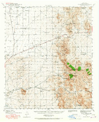
 1996 Tortugas Mountain2002 Print · USGSThe eastern outskirts of Las Cruces in the late 1990s showcase a blend of university expansion and high-desert terrain. Researchers can trace the development of the New Mexico State Univ campus or locate sites like the Standard Mine and Alameda Dam.
 - 1996 Map of Las Cruces, 2002 Print
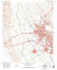
 1996 Las Cruces2002 Print · USGSLas Cruces and the Rio Grande valley are captured here in the mid-nineties, showing the city's expansion alongside historic agricultural tracts. Researchers can trace the layout of Mesilla, locate the St Joseph Cemetery, and follow the AT&SF RR through Mesilla Park.
 - 1996 Map of Picacho Mountain, 2002 Print
 1996 Picacho Mountain2002 Print · USGSDona Ana County’s high desert landscape comes into focus in the mid-1990s as the suburbs and infrastructure west of Las Cruces expand. Researchers can trace land divisions within the Mesilla Civil Colony or locate recreational landmarks like the State Fairground and Sertoma International Raceway.
 - 1996 Map of Organ Peak NW, 2002 Print
 1996 Organ Peak NW2002 Print · USGSLas Cruces meets the Chihuahuan Desert in the mid-nineties as scientific and military installations reshape the landscape. Researchers can trace the boundaries of the White Sands Test Facility and locate remote ranching features like Isaack Lake and Laswell Tank.
 - 2010 Map of Dona Ana, 2010 Print
 2010 Dona Ana2010 Print · USGSCovers Las Cruces, including Doña Ana, Hill, and other nearby areas
 - 2010 Map of Tortugas Mountain, 2010 Print
 2010 Tortugas Mountain2010 Print · USGSCovers Las Cruces, including University Park, Doña Ana County, and other nearby areas
 - 2010 Map of Afton NW, 2010 Print
 2010 Afton NW2010 Print · USGSCovers Las Cruces, including Doña Ana County, United States, and other nearby areas
 - 2010 Map of Picacho Mountain, 2010 Print
 2010 Picacho Mountain2010 Print · USGSCovers Las Cruces, including Doña Ana County, United States, and other nearby areas
Showing maps 1-25 of 51
Top cities near Las Cruces
- Mesilla historical maps
- Doña Ana historical maps
- Butterfield Park historical maps
- Organ historical maps
Top neighborhoods of Las Cruces
Frequently asked questions
- What are the different types of historical maps available for Las Cruces?
- What is the oldest map of Las Cruces?
- Where can I purchase historical maps of Las Cruces for my home or office?
- Where can I download high-res historical maps of Las Cruces?
- Are there historical topographic maps available for Las Cruces?
- Is there historical aerial imagery available for Las Cruces?
- Where are historical maps of Las Cruces sourced from?