1990s Maps of Las Cruces, New Mexico
Explore 6 historic maps of Las Cruces from the 1990s. These maps offer a rare glimpse into what life looked like during the 1990s — showing old roads, neighborhoods, homes, and landmarks that have changed or disappeared over time.
Whether you're researching your family's past, planning a metal detecting trip, or studying how Las Cruces's landscape evolved across the 1990s, these high-resolution maps are a powerful tool for exploring the history of this region.
- Focus on a specific era: All maps on this page are from the 1990s, giving you a focused view of this time period.
- See what’s changed: Compare century-old streets, trails, and buildings to today's modern landscape using overlays and satellite layers.
- Research with precision: Use these maps for genealogy, historical research, land use analysis, or educational projects.
- View, download, or print: Maps are fully viewable online in high resolution, and can be downloaded or printed for your own records.
Start exploring Las Cruces's history through authentic maps from the 1990s. This is your window into the past.
Las Cruces, NM maps
(6)- 1996 Map of Afton NW, 2001 Print
 1996 Afton NW2001 Print · USGSThe high desert of southern New Mexico appears in the late nineties as a landscape defined by survey geometry and industrial utility. Genealogists and historians can trace the New Mexico Principal Meridian and the paths of several desert Pipelines.
 - 1996 Map of Dona Ana, 2002 Print
 1996 Dona Ana2002 Print · USGSSouthern New Mexico agriculture and desert research intersect here in the late twentieth century. Genealogists and local historians can trace the Dona Ana Bend Colony limits and locate sites like the Cem and Wagner Well.
 - 1996 Map of Tortugas Mountain, 2002 Print
 1996 Tortugas Mountain2002 Print · USGSThe eastern outskirts of Las Cruces in the late 1990s showcase a blend of university expansion and high-desert terrain. Researchers can trace the development of the New Mexico State Univ campus or locate sites like the Standard Mine and Alameda Dam.
 - 1996 Map of Las Cruces, 2002 Print
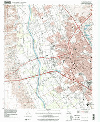 1996 Las Cruces2002 Print · USGSLas Cruces and the Rio Grande valley are captured here in the mid-nineties, showing the city's expansion alongside historic agricultural tracts. Researchers can trace the layout of Mesilla, locate the St Joseph Cemetery, and follow the AT&SF RR through Mesilla Park.
 - 1996 Map of Picacho Mountain, 2002 Print
 1996 Picacho Mountain2002 Print · USGSDona Ana County’s high desert landscape comes into focus in the mid-1990s as the suburbs and infrastructure west of Las Cruces expand. Researchers can trace land divisions within the Mesilla Civil Colony or locate recreational landmarks like the State Fairground and Sertoma International Raceway.
 - 1996 Map of Organ Peak NW, 2002 Print
 1996 Organ Peak NW2002 Print · USGSLas Cruces meets the Chihuahuan Desert in the mid-nineties as scientific and military installations reshape the landscape. Researchers can trace the boundaries of the White Sands Test Facility and locate remote ranching features like Isaack Lake and Laswell Tank.
End of results
Showing maps 1-6 of 6
Top cities near Las Cruces
- Mesilla historical maps
- Doña Ana historical maps
- Butterfield Park historical maps
- Organ historical maps
Top neighborhoods of Las Cruces
Frequently asked questions
- What are the different types of historical maps available for Las Cruces?
- What is the oldest map of Las Cruces?
- Where can I purchase historical maps of Las Cruces for my home or office?
- Where can I download high-res historical maps of Las Cruces?
- Are there historical topographic maps available for Las Cruces?
- Is there historical aerial imagery available for Las Cruces?
- Where are historical maps of Las Cruces sourced from?