1970s Maps of Las Cruces, New Mexico
Explore 3 historic maps of Las Cruces from the 1970s. These maps offer a rare glimpse into what life looked like during the 1970s — showing old roads, neighborhoods, homes, and landmarks that have changed or disappeared over time.
Whether you're researching your family's past, planning a metal detecting trip, or studying how Las Cruces's landscape evolved across the 1970s, these high-resolution maps are a powerful tool for exploring the history of this region.
- Focus on a specific era: All maps on this page are from the 1970s, giving you a focused view of this time period.
- See what’s changed: Compare century-old streets, trails, and buildings to today's modern landscape using overlays and satellite layers.
- Research with precision: Use these maps for genealogy, historical research, land use analysis, or educational projects.
- View, download, or print: Maps are fully viewable online in high resolution, and can be downloaded or printed for your own records.
Start exploring Las Cruces's history through authentic maps from the 1970s. This is your window into the past.
Las Cruces, NM maps
(3)- 1978 Map of Las Cruces
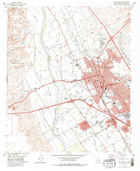 1978 Las Cruces1978 Print · USGSLas Cruces and the Rio Grande valley are shown in detail during the late seventies, a period of steady growth along the railroad. Local historians can trace the irrigation networks of the Leasburg Canal and locate neighborhood landmarks like Mesilla Park and Tortugas.
 - 1978 Map of Dona Ana, 1994 Print
 1978 Dona Ana1994 Print · USGSThe Mesilla Valley in the late seventies reveals a landscape of high-desert peaks and complex Rio Grande irrigation. Trace the development of Doña Ana and the Animal Science Ranch or locate the Cem and Doña Ana-East Picacho Sch near the river.
 - 1978 Map of Picacho Mountain, 1994 Print
 1978 Picacho Mountain1994 Print · USGSThe West Mesa of the Mesilla Valley comes into focus in the late 1970s, showcasing a mix of desert aviation and colonial land grants. You can trace the development of the State Fairground, the Las Cruces International Airport, and historic land divisions like the Mesilla Civil Colony Tract No 2.
End of results
Showing maps 1-3 of 3
Top cities near Las Cruces
- Mesilla historical maps
- Doña Ana historical maps
- Butterfield Park historical maps
- Organ historical maps
Top neighborhoods of Las Cruces
Frequently asked questions
- What are the different types of historical maps available for Las Cruces?
- What is the oldest map of Las Cruces?
- Where can I purchase historical maps of Las Cruces for my home or office?
- Where can I download high-res historical maps of Las Cruces?
- Are there historical topographic maps available for Las Cruces?
- Is there historical aerial imagery available for Las Cruces?
- Where are historical maps of Las Cruces sourced from?