Old Maps of Noria, New Mexico for Genealogy
Trace your family roots with 14 historic maps of Noria. These high-res maps reveal old neighborhoods, homesites, landmarks, and streets — helping you uncover where your ancestors lived and how the area evolved over time.
- Explore historic neighborhoods: Identify where your relatives may have lived in the 1800s or 1900s.
- Compare maps over time: Trace the changes in streets, buildings, and landmarks for multi-generational research.
- Perfect for genealogy & ancestry research: Used by family historians and researchers to map out lineage and migration.
These maps are an incredible resource for exploring your personal connection to Noria's past.
Noria, NM maps
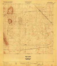
(14)- 1917 Map of Noria, 1963 Print
 1917 Noria1963 Print · USGSSouthern New Mexico’s high desert was a remote ranching and rail frontier in the years following the border conflicts. Genealogists and historians can trace rail stops like Noria and Lanark or find the locations of Herrington's Home Ranch.
 - 1918 Map of Noria
 1918 Noria1918 Print · USGSSouthern New Mexico was a critical rail and ranching corridor during the early twentieth century. Researchers can trace the path of the Southern Pacific railroad through desert outposts like Lanark and the family-owned Herringtons Home Ranch.2 unique versions available
 - 1953 Map of El Paso
 1953 El Paso1953 Print · USGSEl Paso and the border region are shown here in the early fifties, documenting a landscape of shared river life and rising military presence. Genealogists and historians can trace rail-tied communities like Smeltertown, San Elizario, and the grounds of Fort Bliss.
 - 1959 Map of El Paso, 1968 Print
 1959 El Paso1968 Print · USGSEl Paso and the international borderlands come alive in this mid-century survey of the Chihuahuan Desert. Genealogists and historians can trace rail-side settlements like Columbus and Fabens, locate the sprawling Fort Bliss, and explore the geologically unique Kilbourne Hole.2 unique versions available
 - 1964 Map of El Paso
 1964 El Paso1964 Print · USGSThe El Paso and Juarez borderlands are shown in detail during the mid-sixties, from the urban center to the remote volcanic craters of the West Potrillo Mountains. Trace the rail-and-river network through Asarco Smeltertown, the Fort Bliss Military Reservation, and Columbus.
 - 1965 Map of El Paso
 1965 El Paso1965 Print · USGSEl Paso and the Mesilla Valley are shown in the mid-1960s as the region's military and transport infrastructure expanded. Researchers can trace the irrigation network along the Rio Grande, find old border stations like Columbus, and locate Hueco Tanks.
 - 1983 Map of El Paso
 1983 El Paso1983 Print · USGSThe Chihuahuan Desert borderlands come into sharp focus in the early eighties as the binational metro area of El Paso and Ciudad Juarez expands. Genealogists and historians can trace rail lines like the Santa Fe, military grounds at Fort Bliss, and rural valley settlements including Canutillo and Zaragoza.2 unique versions available
 - 1985 Map of Noria
 1985 Noria1985 Print · USGSThe high desert border of southern New Mexico meets Mexico in the mid-1980s, centered on the railroad stop at Noria. Researchers can trace the path of the Southern Pacific railroad and the international boundary near La Joya and Dona Ana Co.
 - 1996 Map of Noria, 2002 Print
 1996 Noria2002 Print · USGSThe international border south of Las Cruces in the mid-1990s is the focus of this trans-boundary survey. Genealogists and historians can trace the sparse outposts of Noria and La Joya along the line between New Mexico and Chihuahua.
 - 2010 Map of Noria, 2010 Print
 2010 Noria2010 Print · USGSCovers Noria, including Juárez, Doña Ana County, and other nearby areas
 - 2013 Map of Noria, 2013 Print
 2013 Noria2013 Print · USGSCovers Noria, including Juárez, Doña Ana County, and other nearby areas
 - 2017 Map of Noria, 2017 Print
 2017 Noria2017 Print · USGSCovers Noria, including Juárez, Doña Ana County, and other nearby areas
 - 2020 Map of Noria, 2020 Print
 2020 Noria2020 Print · USGSCovers Noria, including Juárez, Doña Ana County, and other nearby areas
 - 2023 Map of Noria, 2023 Print
 2023 Noria2023 Print · USGSThe southern desert of Doña Ana County is captured here in the early 2020s, showing a remote landscape shaped by the international border. Researchers can trace the path of A003 Co Rd as it passes the small settlement of Noria just north of the United States of America Estados Unidos Mexicanos boundary.
End of results
Showing maps 1-14 of 14
Top cities near Noria
Frequently asked questions
- What are the different types of historical maps available for Noria?
- What is the oldest map of Noria?
- Where can I purchase historical maps of Noria for my home or office?
- Where can I download high-res historical maps of Noria?
- Are there historical topographic maps available for Noria?
- Is there historical aerial imagery available for Noria?
- Where are historical maps of Noria sourced from?