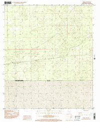
1996 Map of Noria
USGS Topo · Published 2002About this map
Noria sits along the international border in this mid-1990s provisional survey of south-central New Mexico. The landscape is defined by the sharp division of the United States of America Estados Unidos Mexicanos boundary, separating Doña Ana Co from the Mexican state of Chihuahua. To the south across the line, the settlement of La Joya appears in the Mexican interior. The map illustrates a high-desert environment where sparse human activity is restricted to a few isolated outposts and a network of improved and unimproved roads that navigate the arid terrain. This 1996 edition provides a look at the borderlands before modern infrastructure changed the character of these remote crossing points.
Find a feature on this map
8 named features on this map. Tap any name to fly to it.
Don’t see what you’re looking for? This feature index may not catch every label — zoom into the map to look around manually.
Map Details
Editions of this 1996 Noria Map
This is the sole edition of this map. No revisions or reprints were ever made.
Other maps of this area

1917 · Canutillo
USGS Topo · 1:62,500

1917 · Noria
USGS Topo · 1:62,500

1918 · Noria
USGS Topo · 1:62,500

1919 · Canutillo
USGS Topo · 1:62,500

1953 · El Paso
USGS Topo · 1:250,000
1955 · Strauss
USGS Topo · 1:24,000
1955 · La Union
USGS Topo · 1:24,000

1959 · El Paso
USGS Topo · 1:250,000

1964 · El Paso
USGS Topo · 1:250,000

1965 · El Paso
USGS Topo · 1:250,000