1980s Maps of Alamo Hueco, New Mexico
Explore 2 historic maps of Alamo Hueco from the 1980s. These maps offer a rare glimpse into what life looked like during the 1980s — showing old roads, neighborhoods, homes, and landmarks that have changed or disappeared over time.
Whether you're researching your family's past, planning a metal detecting trip, or studying how Alamo Hueco's landscape evolved across the 1980s, these high-resolution maps are a powerful tool for exploring the history of this region.
- Focus on a specific era: All maps on this page are from the 1980s, giving you a focused view of this time period.
- See what’s changed: Compare century-old streets, trails, and buildings to today's modern landscape using overlays and satellite layers.
- Research with precision: Use these maps for genealogy, historical research, land use analysis, or educational projects.
- View, download, or print: Maps are fully viewable online in high resolution, and can be downloaded or printed for your own records.
Start exploring Alamo Hueco's history through authentic maps from the 1980s. This is your window into the past.
Alamo Hueco, NM maps
(2)- 1982 Map of Sentinel Butte
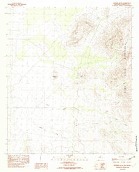 1982 Sentinel Butte1982 Print · USGSThe high desert of Hidalgo County is captured here in the early 1980s, showcasing the isolated peaks and drainage basins of the southern borderlands. Researchers can locate ranching infrastructure like the Pp2 Wind Mill and landmarks such as Sentinel Butte and Alamo Hueco.
 - 1983 Map of Alamo Hueco Mountains
 1983 Alamo Hueco Mountains1983 Print · USGSThe New Mexico-Mexico borderlands in the early eighties reveal a landscape of remote ranching outposts and rugged mountain ranges. Researchers can trace the path of the Continental Divide and locate isolated settlements like Fitzpatricks, San Luis, and the Antelope Wells crossing.
End of results
Showing maps 1-2 of 2
Frequently asked questions
- What are the different types of historical maps available for Alamo Hueco?
- What is the oldest map of Alamo Hueco?
- Where can I purchase historical maps of Alamo Hueco for my home or office?
- Where can I download high-res historical maps of Alamo Hueco?
- Are there historical topographic maps available for Alamo Hueco?
- Is there historical aerial imagery available for Alamo Hueco?
- Where are historical maps of Alamo Hueco sourced from?