1980s Maps of Jim Robinson, New Mexico
Explore 2 historic maps of Jim Robinson from the 1980s. These maps offer a rare glimpse into what life looked like during the 1980s — showing old roads, neighborhoods, homes, and landmarks that have changed or disappeared over time.
Whether you're researching your family's past, planning a metal detecting trip, or studying how Jim Robinson's landscape evolved across the 1980s, these high-resolution maps are a powerful tool for exploring the history of this region.
- Focus on a specific era: All maps on this page are from the 1980s, giving you a focused view of this time period.
- See what’s changed: Compare century-old streets, trails, and buildings to today's modern landscape using overlays and satellite layers.
- Research with precision: Use these maps for genealogy, historical research, land use analysis, or educational projects.
- View, download, or print: Maps are fully viewable online in high resolution, and can be downloaded or printed for your own records.
Start exploring Jim Robinson's history through authentic maps from the 1980s. This is your window into the past.
Jim Robinson, NM maps
(2)- 1982 Map of Tank Mountain
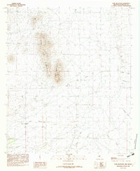 1982 Tank Mountain1982 Print · USGSHidalgo County, New Mexico, is shown here as it was surveyed in the late seventies, focusing on the ranching landscape around the mountain ranges. Researchers can locate essential water infrastructure and landmarks like XT Tank and Little Tank Mountain.
 - 1983 Map of Animas
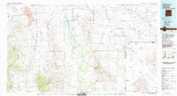 1983 Animas1983 Print · USGSSouthern New Mexico’s Bootheel remains a landscape of high-desert ranching and remote mining districts during the early eighties. Researchers can trace the Southern Pacific Railroad past historic hubs like Animas and Hachita or locate mining sites such as the Gillespie Mine.
End of results
Showing maps 1-2 of 2
Frequently asked questions
- What are the different types of historical maps available for Jim Robinson?
- What is the oldest map of Jim Robinson?
- Where can I purchase historical maps of Jim Robinson for my home or office?
- Where can I download high-res historical maps of Jim Robinson?
- Are there historical topographic maps available for Jim Robinson?
- Is there historical aerial imagery available for Jim Robinson?
- Where are historical maps of Jim Robinson sourced from?