1960s Maps of Columbus, New Mexico
Explore 4 historic maps of Columbus from the 1960s. These maps offer a rare glimpse into what life looked like during the 1960s — showing old roads, neighborhoods, homes, and landmarks that have changed or disappeared over time.
Whether you're researching your family's past, planning a metal detecting trip, or studying how Columbus's landscape evolved across the 1960s, these high-resolution maps are a powerful tool for exploring the history of this region.
- Focus on a specific era: All maps on this page are from the 1960s, giving you a focused view of this time period.
- See what’s changed: Compare century-old streets, trails, and buildings to today's modern landscape using overlays and satellite layers.
- Research with precision: Use these maps for genealogy, historical research, land use analysis, or educational projects.
- View, download, or print: Maps are fully viewable online in high resolution, and can be downloaded or printed for your own records.
Start exploring Columbus's history through authentic maps from the 1960s. This is your window into the past.
Columbus, NM maps
(4)- 1964 Map of El Paso
 1964 El Paso1964 Print · USGSThe El Paso and Juarez borderlands are shown in detail during the mid-sixties, from the urban center to the remote volcanic craters of the West Potrillo Mountains. Trace the rail-and-river network through Asarco Smeltertown, the Fort Bliss Military Reservation, and Columbus.
 - 1965 Map of El Paso
 1965 El Paso1965 Print · USGSEl Paso and the Mesilla Valley are shown in the mid-1960s as the region's military and transport infrastructure expanded. Researchers can trace the irrigation network along the Rio Grande, find old border stations like Columbus, and locate Hueco Tanks.
 - 1965 Map of Columbus, 1967 Print
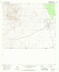 1965 Columbus1967 Print · USGSThe high desert borderlands near the New Mexico-Chihuahua line are captured here in the mid-sixties, centered on the historic town of Columbus. Researchers can trace the Old Railroad Grade, locate the village Cem, and see the footprint of Pancho Villa State Park.2 unique versions available
 - 1966 Map of Columbus SE, 1967 Print
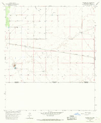 1966 Columbus SE1967 Print · USGSThe high desert along the New Mexico-Chihuahua border comes into focus in the mid-1960s, showing the intersection of international boundaries and ranching life. Genealogists and researchers can trace water-right landmarks like Dean Well, O'Bryan Windmill, and the OLD RAILROAD GRADE.
End of results
Showing maps 1-4 of 4
Frequently asked questions
- What are the different types of historical maps available for Columbus?
- What is the oldest map of Columbus?
- Where can I purchase historical maps of Columbus for my home or office?
- Where can I download high-res historical maps of Columbus?
- Are there historical topographic maps available for Columbus?
- Is there historical aerial imagery available for Columbus?
- Where are historical maps of Columbus sourced from?