1900s (20th Century) Maps of Peruhill, Deming
Explore 6 historic maps of Peruhill from the 1900s (20th Century). These maps offer a rare glimpse into what life looked like during the 1900s — showing old roads, neighborhoods, homes, and landmarks that have changed or disappeared over time.
Whether you're researching your family's past, planning a metal detecting trip, or studying how Peruhill's landscape evolved across the 1900s, these high-resolution maps are a powerful tool for exploring the history of this region.
- Focus on a specific era: All maps on this page are from the 1900s, giving you a focused view of this time period.
- See what’s changed: Compare century-old streets, trails, and buildings to today's modern landscape using overlays and satellite layers.
- Research with precision: Use these maps for genealogy, historical research, land use analysis, or educational projects.
- View, download, or print: Maps are fully viewable online in high resolution, and can be downloaded or printed for your own records.
Start exploring Peruhill's history through authentic maps from the 1900s. This is your window into the past.
Peruhill, Deming maps
(6)- 1915 Map of Deming
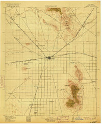 1915 Deming1915 Print · USGSDeming and the surrounding high desert of Luna County were a critical crossroads of Southwestern rail and wagon traffic at the start of the twentieth century. Genealogists can locate family holdings like the 76 Ranch and early social hubs including Midway Iola P O and Tunis School.4 unique versions available
 - 1955 Map of Las Cruces, 1963 Print
 1955 Las Cruces1963 Print · USGSSouthern New Mexico comes into focus during the mid-fifties, showing the growth of Las Cruces alongside major military and scientific installations. Genealogists and historians can trace the Southern Pacific tracks through small rail towns like Cambray and Afton, or locate family sites near Hatch and Deming.3 unique versions available
 - 1958 Map of Las Cruces
 1958 Las Cruces1958 Print · USGSSouthern New Mexico in the late fifties was a landscape of rapid scientific and military growth centered on the Rio Grande. Local historians can trace the development of Las Cruces, the campus of New Mexico A and M College, and remote rail sidings like Aden Siding.
 - 1964 Map of Deming West, 1967 Print
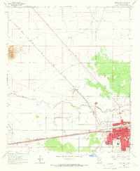 1964 Deming West1967 Print · USGSDeming stood as a bustling rail and desert hub in the 1960s, marked by the intersection of two major transcontinental railroads. Researchers can trace the town's mid-century growth through local landmarks like Holy Cross Cem, the Concentrating Plant at Peruhill, and Mimbres Mem Hospital.
 - 1982 Map of Deming, 1983 Print
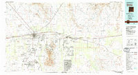 1982 Deming1983 Print · USGSDeming and the surrounding high desert emerge in the early 1980s as a vital transportation and mining corridor. Genealogists and historians can trace the rail sidings of Cambray and Akela or locate the historic Fort Cummings (Ruins) near the Cookes Range.2 unique versions available
 - 1996 Map of Deming West, 2003 Print
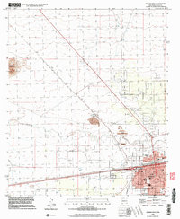 1996 Deming West2003 Print · USGSDeming stood as a bustling rail and industrial crossroads in the late nineties, where the high desert meets a growing urban grid. Genealogists and historians can trace local landmarks like Holy Cross Cem, the Asarco Mill, and the settlement at Peruhill.
End of results
Showing maps 1-6 of 6
Top cities near Peruhill
Frequently asked questions
- What are the different types of historical maps available for Peruhill?
- What is the oldest map of Peruhill?
- Where can I purchase historical maps of Peruhill for my home or office?
- Where can I download high-res historical maps of Peruhill?
- Are there historical topographic maps available for Peruhill?
- Is there historical aerial imagery available for Peruhill?
- Where are historical maps of Peruhill sourced from?