1900s (20th Century) Maps of Three Rivers, New Mexico
Explore 7 historic maps of Three Rivers from the 1900s (20th Century). These maps offer a rare glimpse into what life looked like during the 1900s — showing old roads, neighborhoods, homes, and landmarks that have changed or disappeared over time.
Whether you're researching your family's past, planning a metal detecting trip, or studying how Three Rivers's landscape evolved across the 1900s, these high-resolution maps are a powerful tool for exploring the history of this region.
- Focus on a specific era: All maps on this page are from the 1900s, giving you a focused view of this time period.
- See what’s changed: Compare century-old streets, trails, and buildings to today's modern landscape using overlays and satellite layers.
- Research with precision: Use these maps for genealogy, historical research, land use analysis, or educational projects.
- View, download, or print: Maps are fully viewable online in high resolution, and can be downloaded or printed for your own records.
Start exploring Three Rivers's history through authentic maps from the 1900s. This is your window into the past.
Three Rivers, NM maps
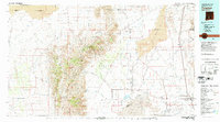
(7)- 1916 Map of Tularosa
 1916 Tularosa1916 Print · USGSNew Mexico ranching and railroading define this pre-war survey of the valley during its early years of statehood. Genealogists and historians can trace family landholdings at Jackson Ranch and Chosa Ranch or follow the path of the El Paso and Southwestern railroad.2 unique versions available
 - 1947 Map of Three Rivers, 1954 Print
 1947 Three Rivers1954 Print · USGSThe Southern Pacific railroad and early military proving grounds define this Otero County landscape in the late forties. Trace family holdings like Falls Ranch and Hatchet Ranch alongside rail stops at Oscura and North Siding.2 unique versions available
 - 1950 Map of Three Rivers
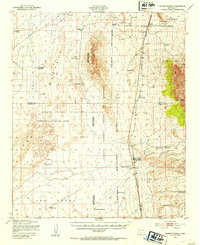
 1950 Three Rivers1950 Print · USGSMid-century Otero County is captured here at the intersection of traditional ranching and the expanding White Sands Proving Grounds. Researchers can trace the Southern Pacific rail line and locate Three Rivers, Falls Ranch, and Aguilar Spring.
 - 1954 Map of Tularosa, 1963 Print
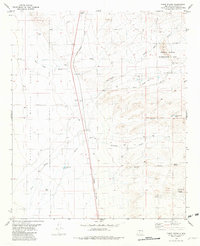
 1954 Tularosa1963 Print · USGSSouth-central New Mexico in the early fifties shows a landscape of desert basins and high peaks under heavy military and water-reclamation use. Trace the path of the Atchison Topeka and Santa Fe Railway past San Marcial and into the massive White Sands Proving Ground.4 unique versions available
 - 1958 Map of Tularosa
 1958 Tularosa1958 Print · USGSSouthern New Mexico in the late fifties shows a landscape of military expansion and deep-rooted river settlements. Trace family history in Truth or Consequences or locate the ruins of San Marcial and the remote Dusty Post Office.2 unique versions available
 - 1981 Map of Tularosa
 1981 Tularosa1981 Print · USGSThe high-desert basin around Tularosa is captured here in the early eighties as a hub of military and rail activity. Trace the Southern Pacific line past Three Rivers or explore the vast White Sands Missile Range.2 unique versions available
 - 1981 Map of Three Rivers, 1982 Print
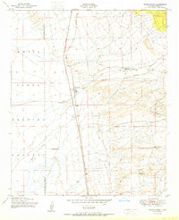
 1981 Three Rivers1982 Print · USGSThe high desert near the Sacramento Mountains comes into focus in the early 1980s, centered on the Three Rivers transit corridor. Researchers can trace the Southern Pacific rail line and locate unique local landmarks like the Petroglyph Site and Crosby Well.
End of results
Showing maps 1-7 of 7
Frequently asked questions
- What are the different types of historical maps available for Three Rivers?
- What is the oldest map of Three Rivers?
- Where can I purchase historical maps of Three Rivers for my home or office?
- Where can I download high-res historical maps of Three Rivers?
- Are there historical topographic maps available for Three Rivers?
- Is there historical aerial imagery available for Three Rivers?
- Where are historical maps of Three Rivers sourced from?