1900s (20th Century) Maps of Art Barns at Eldorado, Santa Fe County
Explore 7 historic maps of Art Barns at Eldorado from the 1900s (20th Century). These maps offer a rare glimpse into what life looked like during the 1900s — showing old roads, neighborhoods, homes, and landmarks that have changed or disappeared over time.
Whether you're researching your family's past, planning a metal detecting trip, or studying how Art Barns at Eldorado's landscape evolved across the 1900s, these high-resolution maps are a powerful tool for exploring the history of this region.
- Focus on a specific era: All maps on this page are from the 1900s, giving you a focused view of this time period.
- See what’s changed: Compare century-old streets, trails, and buildings to today's modern landscape using overlays and satellite layers.
- Research with precision: Use these maps for genealogy, historical research, land use analysis, or educational projects.
- View, download, or print: Maps are fully viewable online in high resolution, and can be downloaded or printed for your own records.
Start exploring Art Barns at Eldorado's history through authentic maps from the 1900s. This is your window into the past.
Art Barns at Eldorado, Santa Fe County maps
(7)- 1952 Map of Seton Village, 1953 Print
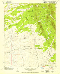 1952 Seton Village1953 Print · USGSSouth of Santa Fe in the early fifties, this landscape is defined by vast historic land grants and the steel of the railroad. Researchers can trace the borders of the Bishop John Lamy Grant or locate old outposts like Ninemile Ranch and Gallina Camp.5 unique versions available
 - 1953 Map of Glorieta, 1955 Print
 1953 Glorieta1955 Print · USGSSanta Fe County at the start of the 1950s shows a landscape where historic trails and modern rails meet in the mountains. Trace the route of the Santa Fe Trail, locate family holdings like Gonzales Ranch, and identify the Glorieta Battlefield Site.6 unique versions available
 - 1954 Map of Santa Fe, 1963 Print
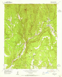
 1954 Santa Fe1963 Print · USGSNew Mexico's high mountains and eastern plains meet in the mid-fifties, showing a landscape defined by the Sangre de Cristo Mountains and the Pecos River. Trace family roots and local history through San Christobal Church, Sena School, and the historic Las Vegas rail corridor.4 unique versions available
 - 1958 Map of Santa Fe
 1958 Santa Fe1958 Print · USGSThe Sangre De Cristo Mountains meet the high plains in the late 1950s, showing a landscape defined by rail corridors and ranching. Genealogists can trace family-named sites like Upton Ranch or visit the Fort Union (Ruins) and Tuloso School.
 - 1966 Map of Galisteo, 1970 Print
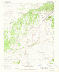 1966 Galisteo1970 Print · USGSThe high-desert basin of Santa Fe County is captured here in the mid-1960s, highlighting the rail corridor and ranching outposts of the period. Researchers can trace historical sites like the Pueblo los Tanos Ruins, the junction at Kennedy, and local landmarks like Thornton Ranch.2 unique versions available
 - 1983 Map of Santa Fe, 1984 Print
 1983 Santa Fe1984 Print · USGSThe high Sangre de Cristo Mountains and the growing state capital define this early 1980s landscape during a period of expanding infrastructure. Researchers can trace historic land patterns and transit routes from Nambe Pueblo and Glorieta Pass to the Atchison Topeka and Santa Fe RR line.
 - 1983 Map of Villanueva, 1984 Print
 1983 Villanueva1984 Print · USGSThe Pecos River valley and its high mesa surroundings are captured here in the early eighties. Researchers can trace historic river settlements like Villanueva and Sena, the route of the Atchison Topeka and Santa Fe railroad, and the high-desert terrain of Glorieta Mesa.
End of results
Showing maps 1-7 of 7
Frequently asked questions
- What are the different types of historical maps available for Art Barns at Eldorado?
- What is the oldest map of Art Barns at Eldorado?
- Where can I purchase historical maps of Art Barns at Eldorado for my home or office?
- Where can I download high-res historical maps of Art Barns at Eldorado?
- Are there historical topographic maps available for Art Barns at Eldorado?
- Is there historical aerial imagery available for Art Barns at Eldorado?
- Where are historical maps of Art Barns at Eldorado sourced from?