1900s (20th Century) Maps of Riley, New Mexico
Explore 7 historic maps of Riley from the 1900s (20th Century). These maps offer a rare glimpse into what life looked like during the 1900s — showing old roads, neighborhoods, homes, and landmarks that have changed or disappeared over time.
Whether you're researching your family's past, planning a metal detecting trip, or studying how Riley's landscape evolved across the 1900s, these high-resolution maps are a powerful tool for exploring the history of this region.
- Focus on a specific era: All maps on this page are from the 1900s, giving you a focused view of this time period.
- See what’s changed: Compare century-old streets, trails, and buildings to today's modern landscape using overlays and satellite layers.
- Research with precision: Use these maps for genealogy, historical research, land use analysis, or educational projects.
- View, download, or print: Maps are fully viewable online in high resolution, and can be downloaded or printed for your own records.
Start exploring Riley's history through authentic maps from the 1900s. This is your window into the past.
Riley, NM maps
(7)- 1954 Map of Socorro, 1972 Print
 1954 Socorro1972 Print · USGSMid-century New Mexico comes into focus as the Rio Grande valley and the surrounding high desert undergo post-war growth. Genealogists and historians can trace old mountain settlements like Tajique and Punta de Agua or locate remote sites like the Torrance Mine.2 unique versions available
 - 1958 Map of Socorro
 1958 Socorro1958 Print · USGSNew Mexico's high desert during the late fifties reveals a landscape of massive land grants and remote mining outposts. Researchers can trace the path of the Atchison Topeka and Santa Fe railroad as it connects Socorro and Belen to industrial sites like the Manganese Mill.
 - 1959 Map of Riley, 1961 Print
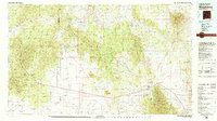
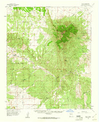 1959 Riley1961 Print · USGSSocorro County ranching and rugged high-desert terrain come into focus in the late fifties. Researchers can trace remote homesteads and landmarks like the Riley settlement, Gray and Ligon Ranch, and the Popotosa Jeep Trail winding toward Ladron Peak.2 unique versions available
 - 1962 Map of Socorro
 1962 Socorro1962 Print · USGSCentral New Mexico comes alive in the early sixties as the rail-and-river corridor of the Rio Grande connects historic pueblos and ranching towns. Local historians can trace the route of the Atchison Topeka and Santa Fe through Belen or locate the Torrance Mine near Mountainair.
 - 1979 Map of Magdalena
 1979 Magdalena1979 Print · USGSSocorro County in the late seventies is shown here as a high-desert landscape of mountain ranges and remote settlements. Genealogists and historians can trace the reach of the Atchison Topeka and Santa Fe Railway and locate sites like Kelly and Guthrieville.
 - 1985 Map of Riley
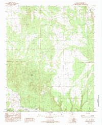 1985 Riley1985 Print · USGSSocorro County, New Mexico, is captured here in the mid-1980s during a period of quiet mineral exploration and land management. Researchers can trace several mineral Prospects and follow the paths of Coyote Draw and the Rio Salado.
 - 1995 Map of Riley, 1998 Print
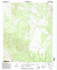 1995 Riley1998 Print · USGSThe high-desert terrain of Socorro County is captured here in the mid-1990s, centered on the settlement at Riley. Researchers can trace the local landscape of Yellow Mountain, locate the community Cem, and identify ranching sites like Comanche Ranch.
End of results
Showing maps 1-7 of 7
Top cities near Riley
Frequently asked questions
- What are the different types of historical maps available for Riley?
- What is the oldest map of Riley?
- Where can I purchase historical maps of Riley for my home or office?
- Where can I download high-res historical maps of Riley?
- Are there historical topographic maps available for Riley?
- Is there historical aerial imagery available for Riley?
- Where are historical maps of Riley sourced from?