1900s (20th Century) Maps of Torrance, New Mexico
Explore 5 historic maps of Torrance from the 1900s (20th Century). These maps offer a rare glimpse into what life looked like during the 1900s — showing old roads, neighborhoods, homes, and landmarks that have changed or disappeared over time.
Whether you're researching your family's past, planning a metal detecting trip, or studying how Torrance's landscape evolved across the 1900s, these high-resolution maps are a powerful tool for exploring the history of this region.
- Focus on a specific era: All maps on this page are from the 1900s, giving you a focused view of this time period.
- See what’s changed: Compare century-old streets, trails, and buildings to today's modern landscape using overlays and satellite layers.
- Research with precision: Use these maps for genealogy, historical research, land use analysis, or educational projects.
- View, download, or print: Maps are fully viewable online in high resolution, and can be downloaded or printed for your own records.
Start exploring Torrance's history through authentic maps from the 1900s. This is your window into the past.
Torrance, NM maps
(5)- 1954 Map of Fort Sumner, 1964 Print
 1954 Fort Sumner1964 Print · USGSEast-central New Mexico's ranching and rail heartland is captured here in the mid-1950s, centered on the strategic junctions of the high plains. Researchers can trace the development of early highway networks and rail towns like Vaughn, Fort Sumner, and the copper operations at Guadalupe Mine.3 unique versions available
 - 1958 Map of Fort Sumner
 1958 Fort Sumner1958 Print · USGSEast-central New Mexico in the mid-fifties is captured here as a sprawling landscape of high mesas and cattle ranching. Researchers can trace the convergence of the Southern Pacific railroad at Vaughn and locate family landmarks like Borica School or Marquez Ranch.
 - 1980 Map of Corona, 1981 Print
 1980 Corona1981 Print · USGSThe high-desert ranching and rail country of Lincoln County is documented here during the early eighties. Genealogists and local historians can trace the Southern Pacific line through Corona, locate the Old Railroad Grade, and find remote outposts like Claunch and Gallinas.
 - 1981 Map of Corona North
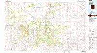
 1981 Corona North1981 Print · USGSCentral New Mexico rail and ranching country comes into focus in the early 1980s, documenting the corridor between the settlements of Torrance and Corona. Genealogists and researchers can trace the Southern Pacific line, the Old Railroad Grade, and local landmarks like the Rodeo Ground.
 - 1995 Map of Corona North, 1998 Print
 1995 Corona North1998 Print · USGSHigh-desert ranching and rail history converge in central New Mexico during the 1990s. Researchers can trace family ranching sites like Brunson Ranch and follow the Southern Pacific tracks through Torrance and Corona.
End of results
Showing maps 1-5 of 5
Top cities near Torrance
Frequently asked questions
- What are the different types of historical maps available for Torrance?
- What is the oldest map of Torrance?
- Where can I purchase historical maps of Torrance for my home or office?
- Where can I download high-res historical maps of Torrance?
- Are there historical topographic maps available for Torrance?
- Is there historical aerial imagery available for Torrance?
- Where are historical maps of Torrance sourced from?