1960s Maps of Royce, New Mexico
Explore 2 historic maps of Royce from the 1960s. These maps offer a rare glimpse into what life looked like during the 1960s — showing old roads, neighborhoods, homes, and landmarks that have changed or disappeared over time.
Whether you're researching your family's past, planning a metal detecting trip, or studying how Royce's landscape evolved across the 1960s, these high-resolution maps are a powerful tool for exploring the history of this region.
- Focus on a specific era: All maps on this page are from the 1960s, giving you a focused view of this time period.
- See what’s changed: Compare century-old streets, trails, and buildings to today's modern landscape using overlays and satellite layers.
- Research with precision: Use these maps for genealogy, historical research, land use analysis, or educational projects.
- View, download, or print: Maps are fully viewable online in high resolution, and can be downloaded or printed for your own records.
Start exploring Royce's history through authentic maps from the 1960s. This is your window into the past.
Royce, NM maps
(2)- 1962 Map of Dalhart
 1962 Dalhart1962 Print · USGSThe High Plains and volcanic peaks of the tri-state area are shown in detail during the early sixties. Genealogists and historians can trace the rail corridors of the Fort Worth and Denver and find industrial sites like the Cactus Ordnance Works or the Beaver Meade & Englewood Grain Elevator.
 - 1966 Map of Royce
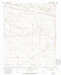 1966 Royce1966 Print · USGSNortheastern New Mexico is shown here in the mid-1960s, where the high plains economy was shaped by ranching and the railroad. Genealogists can locate family landmarks like Rockledge Ranch and Antioch Cem or trace the early path of the COLORADO AND SOUTHERN line.2 unique versions available
End of results
Showing maps 1-2 of 2
Top cities near Royce
Frequently asked questions
- What are the different types of historical maps available for Royce?
- What is the oldest map of Royce?
- Where can I purchase historical maps of Royce for my home or office?
- Where can I download high-res historical maps of Royce?
- Are there historical topographic maps available for Royce?
- Is there historical aerial imagery available for Royce?
- Where are historical maps of Royce sourced from?