1960s Maps of Conklin Station, Conklin
Explore 3 historic maps of Conklin Station from the 1960s. These maps offer a rare glimpse into what life looked like during the 1960s — showing old roads, neighborhoods, homes, and landmarks that have changed or disappeared over time.
Whether you're researching your family's past, planning a metal detecting trip, or studying how Conklin Station's landscape evolved across the 1960s, these high-resolution maps are a powerful tool for exploring the history of this region.
- Focus on a specific era: All maps on this page are from the 1960s, giving you a focused view of this time period.
- See what’s changed: Compare century-old streets, trails, and buildings to today's modern landscape using overlays and satellite layers.
- Research with precision: Use these maps for genealogy, historical research, land use analysis, or educational projects.
- View, download, or print: Maps are fully viewable online in high resolution, and can be downloaded or printed for your own records.
Start exploring Conklin Station's history through authentic maps from the 1960s. This is your window into the past.
Conklin Station, Conklin maps
(3)- 1961 Map of Binghamton East, 1964 Print
 1961 Binghamton East1964 Print · USGSThe Susquehanna River valley transitions from the city to rural hamlets in the early sixties, as transportation networks expand along the water. Genealogists can locate family landmarks such as Binghamton State Hospital, Acre Sch, and the riverside community of Corbettsville.
 - 1963 Map of Binghamton
 1963 Binghamton1963 Print · USGSThe Southern Tier and Catskill peaks are shown in the early sixties as new reservoirs reshaped the valleys. Trace historic rail corridors like the Erie Lackawanna RR and explore lakeside settlements such as Cooperstown and Oneonta.
 - 1968 Map of Binghamton East, 1972 Print
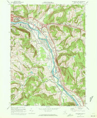 1968 Binghamton East1972 Print · USGSThe Susquehanna River valley south of Binghamton is captured here in the late sixties, showing the interplay of the Erie Lackawanna railroad and new highway interchanges. Genealogists can locate family landmarks like Temple Israel Riverside Cem, Conklin Station, and Corbettsville.2 unique versions available
End of results
Showing maps 1-3 of 3
Top cities near Conklin Station
- Union historical maps
- Binghamton historical maps
- Vestal historical maps
- Johnson City historical maps
- Endwell historical maps
- Chenango historical maps
See more
Frequently asked questions
- What are the different types of historical maps available for Conklin Station?
- What is the oldest map of Conklin Station?
- Where can I purchase historical maps of Conklin Station for my home or office?
- Where can I download high-res historical maps of Conklin Station?
- Are there historical topographic maps available for Conklin Station?
- Is there historical aerial imagery available for Conklin Station?
- Where are historical maps of Conklin Station sourced from?