1960s Maps of Union, New York
Explore 9 historic maps of Union from the 1960s. These maps offer a rare glimpse into what life looked like during the 1960s — showing old roads, neighborhoods, homes, and landmarks that have changed or disappeared over time.
Whether you're researching your family's past, planning a metal detecting trip, or studying how Union's landscape evolved across the 1960s, these high-resolution maps are a powerful tool for exploring the history of this region.
- Focus on a specific era: All maps on this page are from the 1960s, giving you a focused view of this time period.
- See what’s changed: Compare century-old streets, trails, and buildings to today's modern landscape using overlays and satellite layers.
- Research with precision: Use these maps for genealogy, historical research, land use analysis, or educational projects.
- View, download, or print: Maps are fully viewable online in high resolution, and can be downloaded or printed for your own records.
Start exploring Union's history through authentic maps from the 1960s. This is your window into the past.
Union, NY maps
(9)- 1961 Map of Castle Creek, 1963 Print
 1961 Castle Creek1963 Print · USGSBroome County in the early sixties shows a landscape of growing valley towns and hilltop hamlets. Genealogists and local historians can trace family plots at Chenango Valley Cemetery or explore the development of Hillcrest and the Broome County Airport.
 - 1961 Map of Binghamton West, 1964 Print
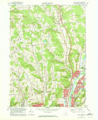
 1961 Binghamton West1964 Print · USGSBinghamton and Johnson City are shown in the early sixties as they developed around the Susquehanna and Chenango Rivers. Researchers can trace historic local institutions like Harpur College, Spring Forest Cemetery, and the Erie-Lackawanna rail lines.
 - 1962 Map of Elmira, 1969 Print
 1962 Elmira1969 Print · USGSThe Finger Lakes region and Southern Tier are captured here during a period of industrial maturity and highway expansion. Researchers can trace the path of the Erie Canal, the footprint of the Seneca Army Depot, and legacy rail lines through Elmira and Ithaca.4 unique versions available
 - 1963 Map of Binghamton
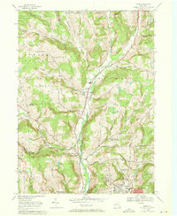
 1963 Binghamton1963 Print · USGSThe Southern Tier and Catskill peaks are shown in the early sixties as new reservoirs reshaped the valleys. Trace historic rail corridors like the Erie Lackawanna RR and explore lakeside settlements such as Cooperstown and Oneonta.
 - 1965 Map of Elmira
 1965 Elmira1965 Print · USGSThe Finger Lakes and Southern Tier regions are captured in the mid-sixties, showcasing a landscape of deep glacial valleys and heavy rail infrastructure. Trace old railroad corridors like the Pennsylvania RR or visit landmarks like Letchworth State Park and the Seneca Army Depot.
 - 1968 Map of Castle Creek, 1972 Print
 1968 Castle Creek1972 Print · USGSBroome County at the end of the sixties shows a region in transition as modern interchanges meet established valley towns. Genealogists can locate family plots in Sacred Heart Cem or Calvary Cem, while historians can trace the Erie Lackawanna rail lines.2 unique versions available
 - 1968 Map of Binghamton West, 1972 Print
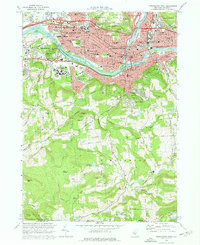 1968 Binghamton West1972 Print · USGSBinghamton and Johnson City are shown during a period of significant postwar growth along the Susquehanna and Chenango Rivers. Researchers can trace family roots at Floral Park Cemetery, locate the expanding State University of New York at Binghamton, or follow the Erie-Lackawanna rail corridor.3 unique versions available
 - 1969 Map of Maine, 1971 Print
 1969 Maine1971 Print · USGSBroome County in the late sixties shows the rural valleys and ridges between Maine and Endwell. Local historians can trace old homesteads and family sites near Maine Cem, Bradley, and the wooded King Hill.3 unique versions available
 - 1969 Map of Endicott, 1972 Print
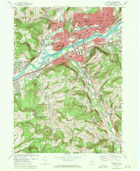 1969 Endicott1972 Print · USGSGreater Endicott and the Susquehanna Valley thrive in this late-sixties record of industrial and suburban growth. Researchers can locate family landmarks from St Marys Cemetery to the Ideal Hospital and trace the influence of the Erie-Lackawanna rail lines.3 unique versions available
End of results
Showing maps 1-9 of 9
Top cities near Union
- Binghamton historical maps
- Vestal historical maps
- Owego historical maps
- Johnson City historical maps
- Endicott historical maps
- Endwell historical maps
See more
Top neighborhoods of Union
- Choconut Center historical maps
- Union Center historical maps
- Westover historical maps
- West Corners historical maps
- Johnson City historical maps
- Endicott historical maps
See more
Frequently asked questions
- What are the different types of historical maps available for Union?
- What is the oldest map of Union?
- Where can I purchase historical maps of Union for my home or office?
- Where can I download high-res historical maps of Union?
- Are there historical topographic maps available for Union?
- Is there historical aerial imagery available for Union?
- Where are historical maps of Union sourced from?