1930s Maps of Kill Buck, Great Valley
Explore 1 historic maps of Kill Buck from the 1930s. These maps offer a rare glimpse into what life looked like during the 1930s — showing old roads, neighborhoods, homes, and landmarks that have changed or disappeared over time.
Whether you're researching your family's past, planning a metal detecting trip, or studying how Kill Buck's landscape evolved across the 1930s, these high-resolution maps are a powerful tool for exploring the history of this region.
- Focus on a specific era: All maps on this page are from the 1930s, giving you a focused view of this time period.
- See what’s changed: Compare century-old streets, trails, and buildings to today's modern landscape using overlays and satellite layers.
- Research with precision: Use these maps for genealogy, historical research, land use analysis, or educational projects.
- View, download, or print: Maps are fully viewable online in high resolution, and can be downloaded or printed for your own records.
Start exploring Kill Buck's history through authentic maps from the 1930s. This is your window into the past.
Kill Buck, Great Valley maps
(1)- 1938 Map of Salamanca, 1954 Print
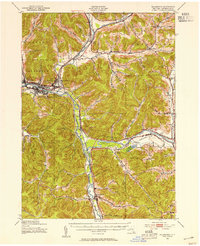 1938 Salamanca1954 Print · USGSIn the late 1930s, this portion of Cattaraugus County was a critical rail and river hub where the Allegheny River meets major transit lines. Researchers can trace the layout of the Allegheny Reservation and locate vanished stop points like Irvine Mills and Kill Buck.2 unique versions available
End of results
Showing maps 1-1 of 1
Top cities near Kill Buck
- Olean historical maps
- Bradford historical maps
- Allegany historical maps
- Salamanca historical maps
- Franklinville historical maps
- Machias historical maps
See more
Frequently asked questions
- What are the different types of historical maps available for Kill Buck?
- What is the oldest map of Kill Buck?
- Where can I purchase historical maps of Kill Buck for my home or office?
- Where can I download high-res historical maps of Kill Buck?
- Are there historical topographic maps available for Kill Buck?
- Is there historical aerial imagery available for Kill Buck?
- Where are historical maps of Kill Buck sourced from?