1920s Maps of Mansfield, New York
Explore 2 historic maps of Mansfield from the 1920s. These maps offer a rare glimpse into what life looked like during the 1920s — showing old roads, neighborhoods, homes, and landmarks that have changed or disappeared over time.
Whether you're researching your family's past, planning a metal detecting trip, or studying how Mansfield's landscape evolved across the 1920s, these high-resolution maps are a powerful tool for exploring the history of this region.
- Focus on a specific era: All maps on this page are from the 1920s, giving you a focused view of this time period.
- See what’s changed: Compare century-old streets, trails, and buildings to today's modern landscape using overlays and satellite layers.
- Research with precision: Use these maps for genealogy, historical research, land use analysis, or educational projects.
- View, download, or print: Maps are fully viewable online in high resolution, and can be downloaded or printed for your own records.
Start exploring Mansfield's history through authentic maps from the 1920s. This is your window into the past.
Mansfield, NY maps
(2)- 1923 Map of Cattaraugus
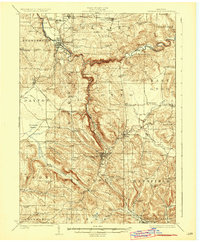 1923 Cattaraugus1923 Print · USGSWestern New York's rugged hill country is captured here during the early twenties, showing a landscape defined by deep creek valleys and a dense network of country schools. Genealogists can trace family locations near landmarks like the State Asylum, Judd Corners, or the dozens of rural schoolhouses such as Rosenburg School.4 unique versions available
 - 1924 Map of Ellicottville
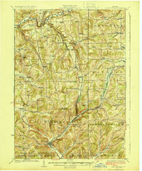 1924 Ellicottville1924 Print · USGSCattaraugus County’s steep valleys and rural schools are preserved here in the mid-1920s, showing the region's transition into the early automotive age. Trace family roots and vanished landmarks like Cascade Park, the Dutch Hill Church, and the Buffalo Rochester and Pittsburgh Railroad corridor.3 unique versions available
End of results
Showing maps 1-2 of 2
Top cities near Mansfield
- Concord historical maps
- Allegany historical maps
- Salamanca historical maps
- Collins historical maps
- Springville historical maps
- Yorkshire historical maps
See more
Top neighborhoods of Mansfield
Frequently asked questions
- What are the different types of historical maps available for Mansfield?
- What is the oldest map of Mansfield?
- Where can I purchase historical maps of Mansfield for my home or office?
- Where can I download high-res historical maps of Mansfield?
- Are there historical topographic maps available for Mansfield?
- Is there historical aerial imagery available for Mansfield?
- Where are historical maps of Mansfield sourced from?