1940s Maps of Venice, New York
Explore 6 historic maps of Venice from the 1940s. These maps offer a rare glimpse into what life looked like during the 1940s — showing old roads, neighborhoods, homes, and landmarks that have changed or disappeared over time.
Whether you're researching your family's past, planning a metal detecting trip, or studying how Venice's landscape evolved across the 1940s, these high-resolution maps are a powerful tool for exploring the history of this region.
- Focus on a specific era: All maps on this page are from the 1940s, giving you a focused view of this time period.
- See what’s changed: Compare century-old streets, trails, and buildings to today's modern landscape using overlays and satellite layers.
- Research with precision: Use these maps for genealogy, historical research, land use analysis, or educational projects.
- View, download, or print: Maps are fully viewable online in high resolution, and can be downloaded or printed for your own records.
Start exploring Venice's history through authentic maps from the 1940s. This is your window into the past.
Venice, NY maps
(6)- 1942 Map of Genoa, 1960 Print
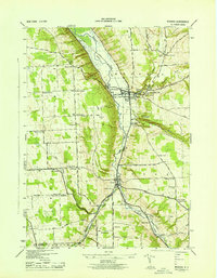
 1942 Genoa1960 Print · USGSSouthern Cayuga County during the early years of the war was a landscape of tightly-knit crossroad hamlets and rural school districts. Genealogists can trace family footprints across Poplar Ridge, Little Hollow, and multiple burial grounds like Maplewood Cem.
 - 1943 Map of Moravia
 1943 Moravia1943 Print · USGSSouthern Cayuga County's valley farms and steep ravines are captured here in the early 1940s, centered on the village of Moravia. Genealogists can trace family connections through numerous landmarks like Baker Cem, Wilson Corners, and a dozen district schools including School No 9.3 unique versions available
 - 1943 Map of Genoa
 1943 Genoa1943 Print · USGSSouthern Cayuga County appears as a network of rural hamlets and creek valleys in the early 1940s. Genealogists can trace family roots through numerous district schools and landmarks like King Ferry, Five Corners, and the Maplewood Cem.
 - 1943 Map of Owasco
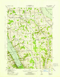 1943 Owasco1943 Print · USGSThe Finger Lakes uplands between Owasco Lake and Skaneateles Lake are captured here during the mid-century. Researchers can trace numerous family-named landmarks and rural burial grounds like Owasco Rural Cem, Valentine Corners, and Frozen Ocean.2 unique versions available
 - 1943 Map of Scipio
 1943 Scipio1943 Print · USGSInland from the shores of Owasco Lake during the early 1940s, this Cayuga County landscape is a meticulous grid of rural townships and family-named corners. Genealogists can trace family footprints across dozens of sites like Scipio Center, St Bernard Cem, and the Emily Howland High Sch.
 - 1949 Map of Moravia
 1949 Moravia1949 Print · USGSThe Finger Lakes uplands around Moravia and Locke are shown here in the late 1940s as a landscape of rural schoolhouses and valleys. Researchers can trace the Lehigh Valley rail line and locate ancestral sites like St Patricks Ch or the Monaghan Cem.
End of results
Showing maps 1-6 of 6
Top cities near Venice
- Auburn historical maps
- Dryden historical maps
- Lansing historical maps
- Seneca Falls historical maps
- Skaneateles historical maps
- Marcellus historical maps
See more
Top neighborhoods of Venice
- East Venice historical maps
- Stewart Corners historical maps
- Venice Center historical maps
- Poplar Ridge historical maps
- Cascade historical maps
- Ledyard historical maps
Frequently asked questions
- What are the different types of historical maps available for Venice?
- What is the oldest map of Venice?
- Where can I purchase historical maps of Venice for my home or office?
- Where can I download high-res historical maps of Venice?
- Are there historical topographic maps available for Venice?
- Is there historical aerial imagery available for Venice?
- Where are historical maps of Venice sourced from?