1960s Maps of Big Flats, New York
Explore 6 historic maps of Big Flats from the 1960s. These maps offer a rare glimpse into what life looked like during the 1960s — showing old roads, neighborhoods, homes, and landmarks that have changed or disappeared over time.
Whether you're researching your family's past, planning a metal detecting trip, or studying how Big Flats's landscape evolved across the 1960s, these high-resolution maps are a powerful tool for exploring the history of this region.
- Focus on a specific era: All maps on this page are from the 1960s, giving you a focused view of this time period.
- See what’s changed: Compare century-old streets, trails, and buildings to today's modern landscape using overlays and satellite layers.
- Research with precision: Use these maps for genealogy, historical research, land use analysis, or educational projects.
- View, download, or print: Maps are fully viewable online in high resolution, and can be downloaded or printed for your own records.
Start exploring Big Flats's history through authentic maps from the 1960s. This is your window into the past.
Big Flats, NY maps
(6)- 1962 Map of Elmira, 1969 Print
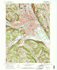
 1962 Elmira1969 Print · USGSThe Finger Lakes region and Southern Tier are captured here during a period of industrial maturity and highway expansion. Researchers can trace the path of the Erie Canal, the footprint of the Seneca Army Depot, and legacy rail lines through Elmira and Ithaca.4 unique versions available
 - 1965 Map of Elmira
 1965 Elmira1965 Print · USGSThe Finger Lakes and Southern Tier regions are captured in the mid-sixties, showcasing a landscape of deep glacial valleys and heavy rail infrastructure. Trace old railroad corridors like the Pennsylvania RR or visit landmarks like Letchworth State Park and the Seneca Army Depot.
 - 1969 Map of Elmira
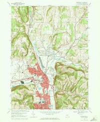
 1969 Elmira1969 Print · USGSElmira and the Chemung River valley are shown at a peak of mid-century industrial and civic development. Researchers can trace family sites at Woodlawn National Cem, locate the Elmira Reformatory, or explore neighborhoods near Elmira Heights.3 unique versions available
 - 1969 Map of Horseheads, 1971 Print
 1969 Horseheads1971 Print · USGSChemung County underwent significant development in the late sixties as industrial hubs like Horseheads and Elmira Heights expanded along major rail lines. Researchers can trace family sites at Maple Grove Cem, locate the Army and Navy Reserve Center, or explore the transit network of the Penn Central and Erie-Lackawanna railroads.
 - 1969 Map of Seeley Creek, 1971 Print
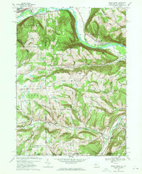 1969 Seeley Creek1971 Print · USGSThe Chemung River valley at the close of the sixties shows a landscape of growing residential developments and deep-rooted rural outposts. Researchers can trace family history through sites like Webb Mills, Dutch Hill Cem, and the prominent Mount Saviour Monastery.3 unique versions available
 - 1969 Map of Big Flats, 1971 Print
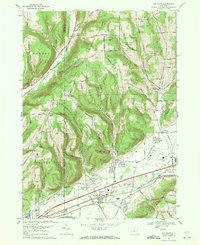 1969 Big Flats1971 Print · USGSThe Chemung River valley is captured here in the late sixties as industrial rail lines and modern aviation transformed the region. Researchers can trace family sites at Rural Home Cem, explore the PENN CENTRAL rail corridor, or locate old crossroads like Smith Corners.3 unique versions available
End of results
Showing maps 1-6 of 6
Top cities near Big Flats
- Elmira historical maps
- Horseheads historical maps
- Corning historical maps
- Southport historical maps
- Erwin historical maps
- Elmira historical maps
See more
Top neighborhoods of Big Flats
Frequently asked questions
- What are the different types of historical maps available for Big Flats?
- What is the oldest map of Big Flats?
- Where can I purchase historical maps of Big Flats for my home or office?
- Where can I download high-res historical maps of Big Flats?
- Are there historical topographic maps available for Big Flats?
- Is there historical aerial imagery available for Big Flats?
- Where are historical maps of Big Flats sourced from?