1940s Maps of New Lebanon, New York
Explore 13 historic maps of New Lebanon from the 1940s. These maps offer a rare glimpse into what life looked like during the 1940s — showing old roads, neighborhoods, homes, and landmarks that have changed or disappeared over time.
Whether you're researching your family's past, planning a metal detecting trip, or studying how New Lebanon's landscape evolved across the 1940s, these high-resolution maps are a powerful tool for exploring the history of this region.
- Focus on a specific era: All maps on this page are from the 1940s, giving you a focused view of this time period.
- See what’s changed: Compare century-old streets, trails, and buildings to today's modern landscape using overlays and satellite layers.
- Research with precision: Use these maps for genealogy, historical research, land use analysis, or educational projects.
- View, download, or print: Maps are fully viewable online in high resolution, and can be downloaded or printed for your own records.
Start exploring New Lebanon's history through authentic maps from the 1940s. This is your window into the past.
New Lebanon, NY maps
(13)- 1943 Map of Housatonic
 1943 Housatonic1943 Print · USGSThe Berkshires and the Housatonic Valley are captured during the war years, showing a landscape of traditional Shaker settlements and growing industrial centers. Trace the routes of the NY NH & H RR and explore sites like Shaker Village, Richmond Furnace, and Rockdale Mills.
 - 1944 Map of Hancock, 1956 Print
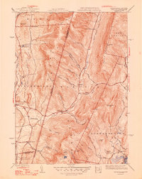
 1944 Hancock1956 Print · USGSThe Taconic borderlands of Massachusetts and New York are captured here in the mid-1940s, showing a landscape of high ridges and rural valleys. Genealogists and hikers can trace old roads to sites like Balance Rock Sch, the Fire Tower on Brodie Mountain, and landmarks like Widow Whites Peak.2 unique versions available
 - 1944 Map of Pittsfield West, 1958 Print
 1944 Pittsfield West1958 Print · USGSThe western Berkshires and the edge of Pittsfield are captured here in the mid-1940s as a landscape of rail-linked villages and highland trails. Researchers can locate family roots near Shaker Village or trace early infrastructure at the Pittsfield Airport and Barkerville.
 - 1945 Map of Stephentown Center, 1958 Print
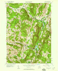
 1945 Stephentown Center1958 Print · USGSRensselaer County's rugged eastern borderlands are captured here just after the war, showing the network of valley hamlets and highland ridges. Genealogists can locate ancestors at Hillside Cem or Sacred Heart Cem and trace the paths through Dunham Hollow and West Stephentown.4 unique versions available
 - 1946 Map of Pittsfield West
 1946 Pittsfield West1946 Print · USGSThe western Berkshires of the mid-1940s are shown here at a moment when communal history and industrial growth converged. Researchers can trace the layout of Shaker Village, locate ancestors at St Josephs Cem, or follow the New York Central RR past Barkerville.
 - 1946 Map of Canaan, 1958 Print
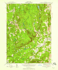
 1946 Canaan1958 Print · USGSThe New York and Massachusetts borderlands appear here in the late 1940s, anchored by the settlements of New Lebanon and Canaan. Researchers can trace family history through sites like the Cemetery of the Evergreens, Darrow Sch, and the Berkshire Industrial Farm.
 - 1947 Map of Stephentown Center
 1947 Stephentown Center1947 Print · USGSRensselaer County at the end of the 1940s reveals a patchwork of highland forests and tight-knit valley hamlets connected by the Rutland railroad. Genealogists can locate family burial sites at Hillside Cem and Sacred Heart Cem or trace old property lines near Stephentown Center.2 unique versions available
 - 1947 Map of Canaan
 1947 Canaan1947 Print · USGSThe Taconic borderlands come alive in this post-war survey of the New York-Massachusetts state line. Genealogists and historians can trace family plots at the Cemetery of the Evergreens or locate the old Darrow Sch and Berkshire Industrial Farm.2 unique versions available
 - 1947 Map of Pittsfield West
 1947 Pittsfield West1947 Print · USGSThe Berkshire foothills in the late 1940s reveal a landscape of growing towns and industrial rail corridors. Genealogists and local historians can trace family-named sites from Lebanon Springs to Barkerville, or locate burials in the St Josephs Cem.2 unique versions available
 - 1948 Map of Stephentown Center
 1948 Stephentown Center1948 Print · USGSRensselaer County’s eastern uplands are shown in detail in the late 1940s, highlighting a landscape defined by state forests and small valley hamlets. Researchers can trace the Rutland rail line or locate family sites near Hillside Cem and Garfield.
 - 1948 Map of Hancock
 1948 Hancock1948 Print · USGSThe Taconic Range and Berkshire foothills meet along the New York-Massachusetts border in the late 1940s. Genealogists and hikers can trace old valley roads and family landmarks like Widow Whites Peak, Gorton Sch, and the village of Hancock.2 unique versions available
 - 1948 Map of Albany, 1951 Print
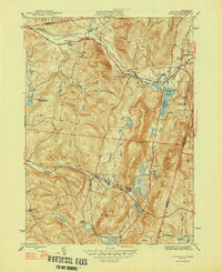
 1948 Albany1951 Print · USGSThe Hudson and Connecticut River valleys are captured here in the late 1940s, showing the vital rail and water corridors of the Northeast. You can trace the Boston and Maine tracks past Mt Greylock or locate early settlements like Great Barrington and Bennington.
 - 1949 Map of Kinderhook
 1949 Kinderhook1949 Print · USGSColumbia County’s landscape is captured here during the post-war era, showing a region shaped by both rail-borne industry and early American history. Genealogists and historians can trace the Boston and Albany tracks to landmarks like the Martin Van Buren Homestead and the Ichabod Crane Sch.
End of results
Showing maps 1-13 of 13
Top cities near New Lebanon
- Troy historical maps
- Pittsfield historical maps
- East Greenbush historical maps
- North Greenbush historical maps
- Schodack historical maps
- Sand Lake historical maps
See more
Top neighborhoods of New Lebanon
- New Britain historical maps
- Lebanon Springs historical maps
- West Lebanon historical maps
- New Lebanon Center historical maps
Frequently asked questions
- What are the different types of historical maps available for New Lebanon?
- What is the oldest map of New Lebanon?
- Where can I purchase historical maps of New Lebanon for my home or office?
- Where can I download high-res historical maps of New Lebanon?
- Are there historical topographic maps available for New Lebanon?
- Is there historical aerial imagery available for New Lebanon?
- Where are historical maps of New Lebanon sourced from?