1950s Maps of Cortlandville, New York
Explore 6 historic maps of Cortlandville from the 1950s. These maps offer a rare glimpse into what life looked like during the 1950s — showing old roads, neighborhoods, homes, and landmarks that have changed or disappeared over time.
Whether you're researching your family's past, planning a metal detecting trip, or studying how Cortlandville's landscape evolved across the 1950s, these high-resolution maps are a powerful tool for exploring the history of this region.
- Focus on a specific era: All maps on this page are from the 1950s, giving you a focused view of this time period.
- See what’s changed: Compare century-old streets, trails, and buildings to today's modern landscape using overlays and satellite layers.
- Research with precision: Use these maps for genealogy, historical research, land use analysis, or educational projects.
- View, download, or print: Maps are fully viewable online in high resolution, and can be downloaded or printed for your own records.
Start exploring Cortlandville's history through authentic maps from the 1950s. This is your window into the past.
Cortlandville, NY maps
(6)- 1950 Map of Elmira
 1950 Elmira1950 Print · USGSThe Finger Lakes region thrived in the late 1940s as a hub of industry and transport. Trace family roots and vanished landmarks near Seneca Lake or explore the rail lines of the Erie RR and the sprawling Seneca Ordnance Depot.2 unique versions available
 - 1955 Map of Homer, 1956 Print
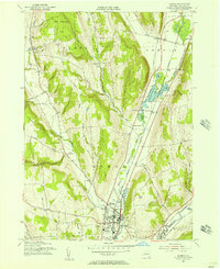 1955 Homer1956 Print · USGSCortland County during the mid-fifties reveals a busy landscape of river-valley rail towns and upland dairy country. Researchers can trace family sites near Homer and Slab City, or locate specific rural institutions like Central High Sch and Glenwood Cem.2 unique versions available
 - 1955 Map of Mc Graw, 1956 Print
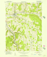 1955 Mc Graw1956 Print · USGSMid-state New York hill country comes into focus in the mid-fifties, showing the intersection of rail transport and rural township life. Genealogists and historians can trace family plots at McGrawville Rural Cem or locate old mill sites like Maybury Mills and Blodgett Mills.4 unique versions available
 - 1955 Map of Cortland, 1956 Print
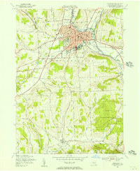 1955 Cortland1956 Print · USGSCortland and Homer are shown in the mid-1950s as thriving valley centers at the confluence of the Tioughnioga branches. Genealogists and local researchers can trace early schoolhouses like Blodgett Mills School No 11, family cemeteries, and landmarks such as the State College.4 unique versions available
 - 1955 Map of Truxton, 1956 Print
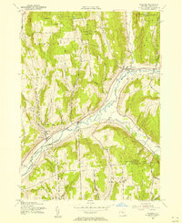 1955 Truxton1956 Print · USGSMid-century Cortland County comes alive in this survey of the Tioughnioga Valley's rail and reforestation corridor. Genealogists and local historians can trace the Lehigh Valley line through old settlements like Crains Mills and East River.4 unique versions available
 - 1958 Map of Elmira
 1958 Elmira1958 Print · USGSThe New York Finger Lakes during the late fifties reveal a complex landscape of glacial geology and industrial growth. Researchers can trace historic transport corridors like the Erie Canal and Erie RR, or locate institutional landmarks like Cornell University.2 unique versions available
End of results
Showing maps 1-6 of 6
Top cities near Cortlandville
- Cortland historical maps
- Dryden historical maps
- Homer historical maps
- Groton historical maps
- Caroline historical maps
- Moravia historical maps
See more
Top neighborhoods of Cortlandville
- South Cortland historical maps
- Polkville historical maps
- Gracie historical maps
- Loring Crossing historical maps
- Munsons Corners historical maps
- Cortland West historical maps
See more
Frequently asked questions
- What are the different types of historical maps available for Cortlandville?
- What is the oldest map of Cortlandville?
- Where can I purchase historical maps of Cortlandville for my home or office?
- Where can I download high-res historical maps of Cortlandville?
- Are there historical topographic maps available for Cortlandville?
- Is there historical aerial imagery available for Cortlandville?
- Where are historical maps of Cortlandville sourced from?