1940s Maps of Cortland West, Cortlandville
Explore 3 historic maps of Cortland West from the 1940s. These maps offer a rare glimpse into what life looked like during the 1940s — showing old roads, neighborhoods, homes, and landmarks that have changed or disappeared over time.
Whether you're researching your family's past, planning a metal detecting trip, or studying how Cortland West's landscape evolved across the 1940s, these high-resolution maps are a powerful tool for exploring the history of this region.
- Focus on a specific era: All maps on this page are from the 1940s, giving you a focused view of this time period.
- See what’s changed: Compare century-old streets, trails, and buildings to today's modern landscape using overlays and satellite layers.
- Research with precision: Use these maps for genealogy, historical research, land use analysis, or educational projects.
- View, download, or print: Maps are fully viewable online in high resolution, and can be downloaded or printed for your own records.
Start exploring Cortland West's history through authentic maps from the 1940s. This is your window into the past.
Cortland West, Cortlandville maps
(3)- 1942 Map of Groton, 1956 Print
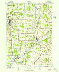 1942 Groton1956 Print · USGSTompkins County rural life is captured here during the early war years, showing a landscape defined by small hamlets and a remarkable number of local schools. Trace the old Lehigh Valley rail line and locate landmarks like the George Junior Republic or Red Mills.2 unique versions available
 - 1943 Map of Groton
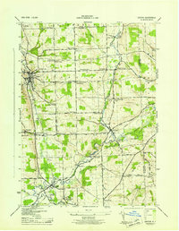 1943 Groton1943 Print · USGSTompkins County during the 1940s is mapped here in detail, showing a landscape of established dairy farms and rail-dependent villages. Genealogists can trace family land via numerous crossroads like Jones Corners and find old schoolhouses including the Mud Schoolhouse Corners.
 - 1944 Map of Cortland
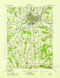 1944 Cortland1944 Print · USGSMid-century Cortland and Homer are depicted here at a peak of rail-based industry and civic growth. Genealogists and local historians can trace family roots through numerous district schools, cemeteries like Rural Cem, and the rural community around Virgil.
End of results
Showing maps 1-3 of 3
Top cities near Cortland West
- Ithaca historical maps
- Cortland historical maps
- Dryden historical maps
- Lansing historical maps
- Cortlandville historical maps
- Homer historical maps
See more
Frequently asked questions
- What are the different types of historical maps available for Cortland West?
- What is the oldest map of Cortland West?
- Where can I purchase historical maps of Cortland West for my home or office?
- Where can I download high-res historical maps of Cortland West?
- Are there historical topographic maps available for Cortland West?
- Is there historical aerial imagery available for Cortland West?
- Where are historical maps of Cortland West sourced from?