
1942 Map of Groton
USGS Topo · Published 1956About this map
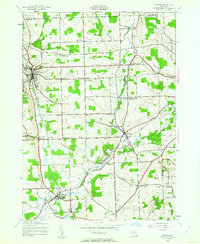
Groton stands as the primary hub of this 1942 landscape, where the Lehigh Valley railroad tracks follow the winding course of the Owasco Inlet. The map reveals a dense network of rural school districts, with fifteen individual schoolhouses like School No 17 and the descriptively named Mud Schoolhouse Corners serving the surrounding agricultural townships. The southern portion of the sheet is dominated by the convergence of Fall Creek, Virgil Creek, and Mill Creek near Freeville, a significant rail junction and home to the George Junior Republic. Local history is preserved through numerous family-named crossroads such as Riggs Corners, Fitts Corners, and Lacey Corners, which reflect the 19th-century settlement patterns of Tompkins County. Small industrial footprints remain visible at Red Mills and Malloryville, while the presence of St Patricks Cem and East Groton Cem provide vital touchstones for genealogical research in this central New York region.
Find a feature on this map
67 named features on this map. Tap any name to fly to it.
Don’t see what you’re looking for? This feature index may not catch every label — zoom into the map to look around manually.
Map Details
Editions of this 1942 Groton Map
2 editions found
Other maps of this area

1898 · Moravia
USGS Topo · 1:62,500

1900 · Dryden
USGS Topo · 1:62,500

1902 · Moravia
USGS Topo · 1:62,500

1903 · Cortland
USGS Topo · 1:62,500

1903 · Harford
USGS Topo · 1:62,500

1906 · Catatonk
USGS Topo · 1:125,000

1943 · Moravia
USGS Topo · 1:31,680

1943 · West Groton
USGS Topo · 1:31,680

1943 · Groton
USGS Topo · 1:31,680
1943 · Sempronius
USGS Topo · 1:31,680