
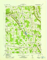
1943 Map of Groton
USGS Topo · Published 1943About this map
Groton stands as the primary hub in this detailed wartime survey of northeastern Tompkins County. The landscape is defined by the winding course of Fall Creek and Mud Creek, which supported early industrial sites like Red Mills. The era’s rural educational and religious infrastructure is remarkably dense, featuring dozens of numbered schoolhouses and cemeteries such as East Groton Cem and St Patricks Cem.
Find a feature on this map
66 named features on this map. Tap any name to fly to it.
Don’t see what you’re looking for? This feature index may not catch every label — zoom into the map to look around manually.
Map Details
Editions of this 1943 Groton Map
This is the sole edition of this map. No revisions or reprints were ever made.
Other maps of this area

1898 · Moravia
USGS Topo · 1:62,500

1900 · Dryden
USGS Topo · 1:62,500

1902 · Moravia
USGS Topo · 1:62,500

1903 · Cortland
USGS Topo · 1:62,500

1903 · Harford
USGS Topo · 1:62,500

1906 · Catatonk
USGS Topo · 1:125,000

1942 · Groton
USGS Topo · 1:24,000

1943 · Moravia
USGS Topo · 1:31,680

1943 · West Groton
USGS Topo · 1:31,680
1943 · Sempronius
USGS Topo · 1:31,680