1900s (20th Century) Maps of Seneca Babcock, Buffalo
Explore 13 historic maps of Seneca Babcock from the 1900s (20th Century). These maps offer a rare glimpse into what life looked like during the 1900s — showing old roads, neighborhoods, homes, and landmarks that have changed or disappeared over time.
Whether you're researching your family's past, planning a metal detecting trip, or studying how Seneca Babcock's landscape evolved across the 1900s, these high-resolution maps are a powerful tool for exploring the history of this region.
- Focus on a specific era: All maps on this page are from the 1900s, giving you a focused view of this time period.
- See what’s changed: Compare century-old streets, trails, and buildings to today's modern landscape using overlays and satellite layers.
- Research with precision: Use these maps for genealogy, historical research, land use analysis, or educational projects.
- View, download, or print: Maps are fully viewable online in high resolution, and can be downloaded or printed for your own records.
Start exploring Seneca Babcock's history through authentic maps from the 1900s. This is your window into the past.
Seneca Babcock, Buffalo maps
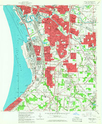
(13)- 1901 Map of Buffalo
 1901 Buffalo1901 Print · USGSBuffalo was a bustling transportation hub at the dawn of the century, where the Great Lakes met the canal and rail networks. Genealogists can trace family roots in early suburbs like Kenmore or locate ancestral sites near Pine Hill Cemetery and Harlem Station.12 unique versions available
 - 1948 Map of Buffalo, 1958 Print
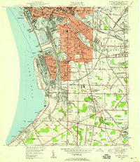
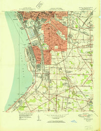
 1948 Buffalo1958 Print · USGSThe Niagara Frontier during the post-war boom years shows the industrial might of the riverfront and the rapid growth of its suburbs. Genealogists and historians can trace neighborhood developments from Brighton Village to Orchard Park, locating landmarks like St Stanislaus Cem and the early Buffalo Airport.
 - 1948 Map of Buffalo NE, 1958 Print
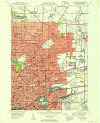
 1948 Buffalo NE1958 Print · USGSBuffalo and its northern reaches are shown in the late 1940s as suburban expansion meets a powerful industrial rail network. Genealogists and historians can trace thousands of individual property blocks and key local landmarks like Offerman Stadium, Forest Lawn Cemetery, and the University of Buffalo.
 - 1948 Map of Buffalo SE, 1959 Print
 1948 Buffalo SE1959 Print · USGSThe Lake Erie shoreline and Buffalo's industrial southern frontier are captured here just after the war. Local historians can trace the rail-heavy landscape of Lackawanna or locate family sites near the Basilica Of Our Lady Of Victory and St Matthews Cem.
 - 1950 Map of Buffalo NE
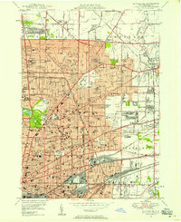
 1950 Buffalo NE1950 Print · USGSBuffalo and its northeastern suburbs in the mid-twentieth century show a dense urban fabric of streetcar-era neighborhoods and burgeoning park systems. Genealogists and historians can trace family locations through dozens of numbered schools, large cemeteries like Forest Lawn, and industrial corridors near Sloan and Walden.
 - 1950 Map of Buffalo SE
 1950 Buffalo SE1950 Print · USGSLake Erie's industrial shoreline and the expanding suburbs of Erie County are captured here at mid-century. Researchers can trace the massive rail infrastructure and maritime landmarks like the South Buffalo Lighthouse or locate family sites at St Matthews Cem and the Basilica Of Our Lady Of Victory.
 - 1960 Map of Buffalo
 1960 Buffalo1960 Print · USGSWestern New York and the Niagara Peninsula thrive during the mid-twentieth century industrial peak. Genealogists and historians can trace family-named points and early settlements from Dunkirk Light to the Allegany Indian Reservation.
 - 1962 Map of Buffalo, 1980 Print
 1962 Buffalo1980 Print · USGSThe Niagara Frontier and Western New York are captured here in the early sixties, showing the vital industrial and maritime nexus between the U.S. and Canada. Researchers can trace the path of the Welland Canal, locate the Allegany Indian Reservation, or find family sites near Chautauqua Lake.2 unique versions available
 - 1965 Map of Buffalo SE, 1967 Print
 1965 Buffalo SE1967 Print · USGSThe southern suburbs of Buffalo come alive in the mid-sixties, from the industrial lakefront at Lackawanna to the growing reaches of Orchard Park. Genealogists and local historians can trace family roots through neighborhood landmarks like Holy Cross Cemetery and Immaculata Academy.
 - 1965 Map of Buffalo NE, 1967 Print
 1965 Buffalo NE1967 Print · USGSThe Buffalo suburbs were in full expansion during the mid-sixties as new expressways cut through established neighborhoods. Researchers can trace family sites near Forest Lawn Cemetery, the War Memorial Stadium, or the early campus of the State University at Buffalo.
 - 1967 Map of Buffalo
 1967 Buffalo1967 Print · USGSWestern New York and the Lake Erie shoreline are shown here during the mid-1960s industrial peak. Researchers can trace the massive rail networks of the Erie Railroad, locate the Cattaraugus Indian Reservation, or find historic sites like Fort Erie.
 - 1973 Map of Buffalo
 1973 Buffalo1973 Print · USGSWestern New York and Ontario's Golden Horseshoe meet in the early seventies, spanning from the industrial waterfronts of Buffalo to the hills of Allegany State Park. Trace the paths of the Welland Canal and Erie Lackawanna railroad through the lakefront towns of Dunkirk and Port Colborne.
 - 1984 Map of Buffalo, 1985 Print
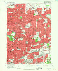
 1984 Buffalo1985 Print · USGSWestern New York's industrial and transport hubs are in full view during the mid-eighties, from the Lake Erie waterfront to the Genesee Valley. Researchers can trace the legacy of the Erie Canal, find ancestral sites like Mount Calvary Cem, or locate the Attica Correctional Facility.2 unique versions available
End of results
Showing maps 1-13 of 13
Frequently asked questions
- What are the different types of historical maps available for Seneca Babcock?
- What is the oldest map of Seneca Babcock?
- Where can I purchase historical maps of Seneca Babcock for my home or office?
- Where can I download high-res historical maps of Seneca Babcock?
- Are there historical topographic maps available for Seneca Babcock?
- Is there historical aerial imagery available for Seneca Babcock?
- Where are historical maps of Seneca Babcock sourced from?